Friday, March 25, 2011

Visions West, a reprise

Back in January I went to the opening of the exhibition Visions West: 19th Century Expedition Arts at the Arvada Center for the Arts and was so impressed that I had to write a enthusiastic review in this blog. Well, the exhibit is going to be closing in just over a week, so now is the time to visit if you haven't yet!

The exhibition uses prints from the Graham and Barbara Curtis Collection. Mrs. Curtis and her daughter Kay Hunsaker were at the opening and I had the pleasure of meeting them. I asked Kay if she would answer a few questions about her parents and their collection and she kindly agreed.

Tell me a bit more about the collection.

It was my father's passion but my mother was very supportive and in the beginning, she learned to matte so that she could help him frame. The theme of his collection was the artistic documentation of the exploration, discoveries, and development of the American West. The original title he used for the collection was "Manifest Destiny, Exploration and Creation of the Nation."

How and when did your father start collecting?

Dad, a Geologist and hard rock miner at heart, always had a love of the Rocky Mountains, the mineral belt, and the exploration of them. Early on, he read about the West, and as he got older he started collecting antique geology and exploration books.

He then got the idea to share his love of America by giving "educational and enlightening" Bi-Centennial gifts in the form of western exploration lithography. While looking for suitable prints, he realized the extent of the availability, and the real treasures to be had. He found smaller, lesser known pieces of interest but when he found the "Rocky Mountains" by Bierstadt, he realized that famous prints could be obtained and that started his quest.


Were there types of prints or artists which he particularly liked?

Chromolithography is his favorite type, for he liked the bright, clear colors, but hand-tinting will always have a special place in his heart. Audubon's prints were his particular favorites as he always mentions them first, then adds Catlin, Bodmer, Bierstadt, and Moran. In truth, he has always loved birds and became a real "birder" after he acquired these prints.


What are his favorite prints?

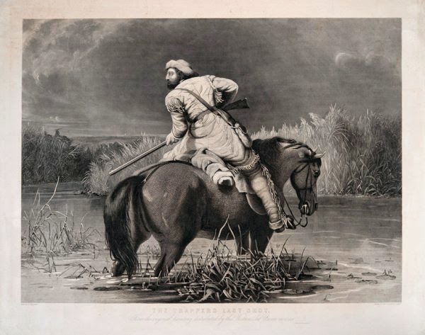
Audubon’s Virginia Partridge and the Male Wild Turkey, George Catlin’s Buffalo, William Ranney’s Trapper's last Shot, Thomas Moran's Grand Canyon, and Albert Bierstadt’s Rocky Mountains.


Was there any print he was looking for a long time and finally got?

The Currier print “The Last War Whoop.” He acquired it just this past August. He had first seen it at the Buckhorn Exchange in Denver, but didn't get it. He quit looking for the print in the last few years but I located it and helped him purchase it.

There is still one he wishes he had gotten and that is the Jolly Flatboat Men by George Caleb Bingham. I found one but it is just too expensive at $15K!

When was the collection first put on display and where else has it been shown?

It was first displayed by the Arvada Art Museum for six weeks in 1986. The museum was pretty new and their staff was small. Dad helped them paint the walls in preparation, Mom and Dad both helped them hang pictures, and assisted in the cost of advertising.

Parts of the collection were also displayed at the Golden, CO Heritage Museum about 1987 & 1988, in the lobby of a bank in Downtown Denver during Denver's Western Heritage awareness, in 1993 or 1996, and in the Littleton Museum twice, in 2006 and 2008.

I wish I had had the opportunity to meet Mr. Curtis, but seeing this super collection in this excellent exhibit did give me a sense of his love and knowledge of the material. Anyone interested in Western prints should make it a point to head over to Arvada to see the collection before it closes on April 3. More information can be found on the Arvada Center's web site.

Wednesday, March 23, 2011

The American West in illustrated newspapers

By 1848, the United States had expanded to encompass the entire central part of the North American continent between the Atlantic and Pacific Oceans and the attention of Americans began to turn to the vast trans-Mississippi West. The emigrants to Oregon and the California gold rush from the 1840s were joined at the end of the next decade by those heading to the Pike’s Peak gold fields or the Comstock Lode. The end of the Civil War saw the building of railroads across and around the West, a region which attracted new emigrants who were at loose ends after the war or simply looking for new opportunities.

The trans-Mississippi West was essentially unknown to Americans when Thomas Jefferson purchased the French Louisiana territory in 1803, and it slowly revealed its secrets beginning with the Lewis & Clark expedition, followed over the years by other government and private explorations. The economic and political need to build a trans-continental railroad generated a spate of exploring parties across the plains and Rocky Mountains in the years before the Civil War, which resulted in a number of publications containing some of the first views of the West available to Americans east of the Mississippi.

As the reports of explorers, emigrants and travelers to the West trickled back east, Americans developed a fascination with this “wild” and far-away U.S. territory. However, first-hand images were hard to come by. There were the illustrations in the government railroad survey reports and in a few view portfolios produced for the elite by artists such as Karl Bodmer and George Catlin. These sources for images of the West, however, were limited in number and scope. Most of the general public did not have access to many, if any, of these views and there were many aspects of life in the region not pictured at all in these sources, which thus did not really meet the demand of Americans to have images of the West.

This demand, however, was well met by a wonderful series of images published in popular illustrated newspapers. This type of newspaper first appeared with The Illustrated London News, founded in 1842, and in the 1850s, a number of American papers followed, becoming hugely popular by the 1860s and 70s. The success of these newspapers lay in their wood-engraved illustrations. These prints were wide-ranging in their coverage of events, places, things and persons of interest to the readers, and they were extremely timely in their appearance, often being issued within two weeks of when the images were first drawn. Readers found it new and exciting to be able to have, within days and at an affordable price, a first-hand view of a disaster from across the country, to gaze on an image of a just constructed bridge, or to see contemporary pictures of far-away places…such as the American West.

The fact that these prints were “merely” illustrations in a newspaper and were issued in huge numbers has led some to dismiss them as unworthy of study or ownership. However, most of the pictures of the American West from this source were drawn by skilled artists, they are based on first-hand observation, and they provide some of the only contemporary images of these scenes available to readers at the time, and of course, to us today.

American and British newspapers sent a number of expert artists to the West to document this frontier for their readers. These artists included Frederic Remington, Charles Graham, R.F. Zogbaum, Thomas Moran, Paul Frenzeny and Jules Tavernier. Not only were events and places depicted, but the quotidian events of emigrants and settlers were also pictured, providing a rich, contemporary, generally accurate, and unique collage of nineteenth century life in the American West.

Friday, March 11, 2011

Promoting Knowledge


I love prints of most types, but I have a particular fondness for prints that are fun but not too expensive. Such prints provide a way for people to have original art on their walls, items that are real antiques with historic interest, without spending the a huge amount to get them. I have just put together a window for the Denver shop with one group of such prints, those issued by the “Society for Promoting Christian Knowledge.”

Quite a mouthful isn’t it? I will discuss this society, and another similar group below, but first I want to explain a bit about these cool prints. These are from series called “Plates Illustrative of Natural History.” They are small folio (about 10 x 12) wood engravings with original hand color. They were issued by the Society for Promoting Christian Knowledge between 1845 and 1847 and they illustrate fauna from around the world. These prints were sold individually, either “plain” or “coloured,” and also in bound volumes.

Each print shows a bird, animal, reptile or fish portrayed in an unthreatening, even anthropomorphic manner. The images are fairly accurate, though somewhat crude and certainly humanized to some extent, and the fauna are generally placed into a natural setting. Each print has text below the image about the animal depicted, text that has a mildly religious bent.

This is not surprising for a society designed to promote Christian knowledge. The society was founded in 1698 as an arm of the Church of England. It produced theological books as well as popular works on science, travel, biography, fiction and natural science. All their works were aimed at the literate middle and working class. It is clear that these prints were likewise aimed at the children of this audience, to help spread general knowledge (with a Christian bent). I think they are fun in appearance and their history makes them particularly interesting.

These prints represent an interesting aspect of the British upper class, viz., their concern to spread knowledge to those less advantaged. The British upper class certainly believed that there was a natural difference between themselves and those of the working and middle classes, but the nineteenth century was a period both when some of the lower classes were able to raise themselves up, but also when the wealthy businessmen of the Industrial Revolution needed a relatively educated working class to help run their businesses and the country. Thus the elite had moral and business reasons to help promote knowledge to the middle and working classes.

Another group of similar intent was the Society for the Diffusion of Useful Knowledge (another mouthful), often referred to as the SDUK. This wonderful English enterprise, which had close ties to University College, London, was, similarly to the society just discussed, devoted to the spreading of up-to-date information and the enhancing of understanding for the working and middle classes.

Many of its publications were sold in only small numbers, though its Penny Magazine was quite popular, with a circulation of about 200,000 at its peak. The middle class did respond to some extent to its scientific publications, but the working class remained mostly uninterested. The society started in 1829, but went bankrupt in 1837, though some of its publications were picked up and continued to be published by others.

Interestingly, a similar organization, the Boston Society for the Diffusion of Useful Knowledge, modeled on the SDUK, was established in 1829 “to promote and direct popular education by lectures and other means. Besides its lectures, the Boston SDUK published a series of scholarly works as part of the American Library of Useful Knowledge, but the society was no longer active by mid-century.

Perhaps the most famous of the publications of the SDUK were its maps, which were issued from 1829 until 1844, separately and in a two volume atlas. These maps were very precise, based on the “latest” information and regularly updated.

Included in the series were 51 city maps, providing some of the best images of the cities of the work in the early 19th century. The maps/atlases were among the most successful of the SDUK publications, being issued in as many as 13,500 copies at the peak. The SDUK maps continued to appear as late as 1885, but by other publishers and in the later versions printed by lithographic transfers from the original steel plates.

Thursday, February 24, 2011

Early prints and maps of Philadelphia & Denver

For almost three decades I sold prints and maps in Philadelphia, and now for about half a year I have done the same in Denver. Any reader of this blog knows that my particular interest with this material lies in its historical nature and I have been lucky in that the histories of both places I have worked have been well represented in prints and maps.

Of course, the history of Philadelphia is over twice as long as that of Denver, but from its early days as a wintering ground for Native Americans, then as the focus of Pike’s Peak Gold Rush, through to its development as one of the most vibrant cities in the country, Denver has a history that is both complex and fascinating.

History is everywhere in Philadelphia, with centuries old buildings and historic sites of national import scattered thick on the ground. There are also some of the most important American institutions with an historical bent located in Philadelphia, such as the Library Company and Historical Society of Pennsylvania. The history of Denver is far less obvious, but it is still there for those with an interest, and in the Historical Society of Colorado and the Denver Public Library’s Western Collection, Denver holds its own with institutions of historical import.

In my time here, I have found that while the specifics of their stories are very different indeed, Philadelphia and Denver are similar in that both of their histories are rich and are an important part of the fabric of the cities. (This is, of course, a good thing as we have opened a shop in Denver!) One thing I have noticed, however, is that the two populations have a very different approach to the views and maps of their locations.

In my opinion, Philadelphia has the most interesting and important body of antique views of any American city. From the earliest printed views in the mid-eighteenth century, leading to William Birch’s landmark City of Philadelphia, through the wonderful series of views by Cephas Childs and J.C. Wild, continuing past the commercial lithographs of post-Civil War period to an extensive body of images of the Centennial, the views of Philadelphia are rightly known as comprising a unique and important body of American iconography.

Philadelphians are quite aware of this fabulous graphic wealth. There are great repositories of Philadelphia views at its many cultural institutions, exhibits on the topic are regularly on display, and there is an impressive body of reference works on Philadelphia views, from Martin Snyder’s City of Independence to the forthcoming Philadelphia on Stone from the Library Company. Furthermore, there is a strong group of knowledgeable collectors and scholars with an interest in this topic.

Somewhat in contrast, while there is a significant body of early maps of Philadelphia and eastern Pennsylvania, there is not nearly the interest in regional maps as there is in views. There are certainly less collectors of Philadelphia and Pennsylvania maps than there are of views of the same area and there have been few exhibitions and no significant reference books on the subject. Sure there are great maps and some serious collectors, but these pale in comparison to the comparable print collections and collectors.

I think there are a number of reasons for this. In terms of Philadelphia maps, there are far fewer early maps of note than there are important early views. Also, most of the early maps of Philadelphia show only Center City, making them of less interest to the large population that lives outside this small locale. And, as I have written about elsewhere, maps of Pennsylvania are notoriously unloved.

What has struck me since my move, is that the attitude of locals here towards views and maps of Denver and Colorado is almost the inverse of that of those in the Delaware Valley toward views and maps of Philadelphia and Pennsylvania. Here, it is maps which generate the most enthusiasm, with views surprisingly under-appreciated.

There is an notably large contingent in the Denver area who are quite keen on maps of the region. The Rocky Mountain Map Society is one of the most active in the country, with many of its members impressively knowledgeable on various western map related topics. And this applies to those who wander into our shop; whereas in Philadelphia we are often answering queries about views, here it is usually maps and more maps!

Probably a lot of this is explained by the fact that the cartographic history of Colorado and Rocky Mountains is really more interesting and varied than that of eastern Pennsylvania. Until the early nineteenth century, there was essentially little or nothing shown on maps of this region, but then a number of expeditions were sent out to the West, leading to the gradual mapping of Colorado and the Rockies. The post-Civil War railroad surveys and other expeditions slowly filled in the topography of the area, so the maps from different years showed interesting progress. And the political development of the trans-Mississippi West went through a whole series of configurations from 1848 to the end of the century, each new map again providing an interesting contrast to those before.

Thus the interest in maps out here is no surprise. As I wrote in an earlier blog, I am having a wonderful time learning about the exploration and settlement of the region, studying how it is depicted on the hundreds of different maps in the second half of the nineteenth century. What did surprise me, on the other hand, is how little interest or knowledge there is about the early printed views of Denver and Colorado.

As I said, in Philadelphia there is an immense amount of interest in and knowledge of the printed views of the area, whereas in Denver there seems to be relatively little of either. Now I do have to admit that this does not seem to apply to the photography of the West, which is a fascinating subject about which I know rather little. But when you are talking about engravings or lithographs of Denver and Colorado, it just doesn’t seem to be something about which people out here are particularly excited.

That isn’t to say that there isn’t some interest in some views of the area. A.E. Mathews’ Pencil Sketches of Colorado are well known and desirable, and many of the map collectors in the area love bird’s eye views, but I find surprising apathy with reference to the more mundane, but still wonderful views of the area from the 1860s to 1900.

Just to give one example, I have talked to a lot of people out here and have yet to find anyone who knows what the first printed view of Denver is. I find that pretty amazing. Denver was only founded in 1858 and there are only so many prints done of the place before, say, 1870, so I would have thought people would know about this, and care!

Some of the lack of interest may be that there are not that many early views of Denver and Colorado, and other than Mathew’s set, most of those are wood engravings from illustrated newspapers. As I have written earlier in this blog, I think illustrated newspaper prints are historically and visually wonderful graphic images and so to me these early views of Denver are terrific, but I guess they haven’t really inspired enthusiasm in the general public.

I am hoping to change that by putting together as much of a history on the topic as possible. There is a recently published book, Illustrations of Historic Colorado, which does include an interesting collection of printed images of the state (most from illustrated newspapers), but I think this topic needs to be further explored and publicized. I plan to do some of this in this blog, but eventually I hope to get something more substantial published. And, by the way, I think I know what the first printed view of Denver is, a topic I will discuss in a forthcoming blog…

Friday, February 4, 2011

Map Fair & Map Museum

While most of the US is suffering under cold & snowy weather, things look pretty nice down in Miami. This weekend there is a great reason to visit besides the great weather, the 2011 Miami Map Fair. Run by and held in the Historical Museum of South Florida, this is the preeminent map event of the year. 50 exhibitors are showing their wares on Saturday and Sunday, including many of the top map dealers in the world.

For the last four years I have been representing The Philadelphia Print Shop at the fair, but this year my partner, Donald H. Cresswell, will be attending instead. I envy him, for not only is the largest collection of available antique maps on display, but many of our friends in the business are either exhibiting or visiting. If you like antique maps, this is definitely the place to be (and don't forget your suntan lotion!).

One of the people who offen attends the map fair will be David J. Morgan, who just over a year ago opened a new non-profit museum, the CARTE Museum. Located at 2347 Christian Street in Baton Rouge, this museum was developed to make available to the public Dave's amazing collection for both research and exhibition. "Carte" is, of course, the French word for map, but Dave uses it also as an acronym for Cartographic Acquisition, Research, Teaching and Exhibition museum.

Dave's collection has been built over the past 40 years and its focus is on the Gulf Coast, though it is also strong in maps showing the political development of the United States. The collection includes complete atlases, books with cartographic content, and maps from atlases and separately issued. So far two exhibitions have been mounted, one of the discovery of the Mississippi River from 1513 to 1764, and the other on West Florida. Next week, the museum is opening a new exhibition "Mapping the Mississippi River and Its Tributaries," which covers the period from about 1750 to 1820. Dave is also planning a "jam-up Louisiana Statehood bicentennial exhibit" with an opening reception on April 30, 2012.

The museum is open to the public on Wednesdays from 9 to 5 or by appointment. Inquiries can be addressed to info@cartemuseum.org.

Thursday, January 27, 2011

Visions West exhibition

From the beginning of the nineteenth century, with the Louisiana Purchase, through the rest of the century, Americans have been fascinated by the trans-Mississippi West. This fascination created a ready market for images of the American frontier, a market that was served by a plethora of artists and printmakers.

I have always been interested in depictions of the American West by those who were early travelers there, an interest which has become particularly keen with my move to Denver. I have begun to delve past those prints which I have studied for years, by artists such as George Catlin, Karl Bodmer, Albert Bierstadt, and Thomas Moran, and learn more about the many other artists who traveled to the West on private and government explorations. Thus it was that I was especially pleased to hear of a new exhibition opening up just a few miles from our shop in Denver on the subject of images of the frontier West.

The exhibit is entitled "Visions West: 19th Century Expedition Artists," and it is running from now until April 3rd at the Arvada Center for the Arts and Humanities. I was able to attend the opening a couple of weeks ago and I was surprised and absolutely delighted at what a tremendous exhibit it is.

The theme of the exhibit is nineteenth century printed images of the American West done by on-the-spot artists. The prints in the exhibit are from the collection of Graham Curtis (about whose collection I will be writing a blog in the near future), which were generously loaned to the Arvada Center by Graham and Barbara Curtis with the help of their daughter Kay Hunsaker. The quality, variety and scope of the prints in the exhibit are amazing, making this an exhibition which anyone interested in the topic has to try to come and view.

The big names--Catlin, Bodmer, Bierstadt, Audubon, Moran--are all there, but the real strength in the exhibit are all the less well known, but equally important artists who documented the West between 1822 and 1883. Some of these artists, such as Seth Eastman, Peter Rindisbacher, and A.E. Mathews, were not part of Government expeditions, but most of the artists whose prints are on display were part of various explorations sent out by the Federal government. These include images by artists such as James W. Abert, John Mix Stanley, Samuel Seymour, John J. Young, Arthur Schott and many more whose accurate, first-hand images provide us with a window on the American West while it was still a "wild frontier."

The exhibition in Arvada is very nicely presented. The prints are arranged by artist, rather than date, and this allows one to look at some of these familiar prints from a new perspective, focusing on the artists, not so much the expeditions. The staff has written informative text on each artist and his work, and so the exhibit is a feast for the mind as well as the eye. All involved should be proud of this wonderful exhibit and again I encourage anyone who can to stop by to see the exhibit before it closes on April 3rd.

Wednesday, January 19, 2011

On April 12, 1861, the first shots were fired on Fort Sumter in Charleston Harbor, South Carolina, beginning the American Civil War, a conflagration which raged for almost exactly four years before, on April 9, 1865, Lee surrendered to Grant at Appomattox Court House, Virginia. The Civil War, as much as the American Revolution, was a defining event in American history, and this conflict has always figured large in the awareness of the American public.

The 150th anniversary of the Civil War will generate renewed interest in the war, with many events, texts, and other media pouring forth this year. As I am particularly interested in historical prints, I have always been a student of contemporary prints of the Civil War. Thus, I have decided to jump on the bandwagon and produce a section of our web site which will specifically consider how the war was pictured in contemporary printed images. This section of our site is called A Nation Divided.

The Civil War took place at a time when two significant historical trends combined to make the relevance of prints particularly important. First was the development, in the nineteenth century, of a growing percentage of the American population which both was literate and had an interest in and the wealth to afford books, magazines, newspapers, and prints for the home. The other trend was the development of printmaking processes that allowed for the relatively inexpensive production of large numbers of printed pictures and maps.

So, a century and a half ago, as the United States made its inevitable way towards the cataclysm which would tear the nation apart, these important historical trends made it so that printed images would become one of, if not the most important means by which the general public would follow the war. Thousands of portraits of political and military leaders, patriotic and partisan images, and scenes of the events and places of the war were printed and disseminated around the country (mostly in the North), providing many Americans with much of their understanding of what was going on in the war. These printed images provided one of the main threads in the fabric of Americans' lives from 1861 to 1865.

Thus it is that I believe the study of contemporary printed images of the Civil War is crucial to gain insight into that traumatic event in our nation's history. Not only do these pictures show us today what those people, places and events looked like (although not by any means always accurately), but also it is only through an awareness of these prints that we can gain any true understanding as to how Americans of the time saw the war.

An important part of the intent of this section of our web site is that it be a useful reference source for those interested in the topic, exploring the history, nature and impact of contemporary printed images of the Civil War. We will put up pages on general topics, such as portraits, cartoons, etc., but a main part of the web site will be a monthly account of the events of the war 150 years ago, with a consideration of the prints showing those events.

This web site is also, of course, intended as a sales tool for our shop. Thus we will include images and descriptions of prints and maps we have in our inventory, along with images which are important to the topic at hand, even if we do not have them for sale.

I welcome comments and corrections. As an historian and printseller, there are few subjects as important to my work and the shop as the prints of the Civil War. I would love to spread knowledge of and interest in this fascinating subject.