It has been a while since I’ve written about mythical geography, so today I’m going to look at a myth which appeared in the mid-sixteenth century and which lasted for about a century and a half, that is, the geographic error of showing a mountain range running east to west across the southern part of today’s United States.
This myth had its origins in the reports of the explorations of Hernando De Soto. De Soto was the governor of Cuba and was given a license by the Spanish King to explore “Florida,” which was the name applied to the essentially unknown land north of Cuba which had been discovered by Ponce de León in 1513. De Soto set sail in May, 1539, landing in today’s Tampa Bay with 600 men. He explored to the north and then west, discovering the Mississippi River in May 1541. De Soto died the following year, with the survivors of his expedition sailing down the Mississippi and then along the coast to Spanish settlements in today’s Mexico.
De Soto had set off to the north from the Gulf until he ran into the Appalachian mountains in the area where today's North and South Carolina and Georgia meet. The expedition then marched in a west-southwest direction, following the foothills and this seems to have led to the conception of a range of mountains running across the continent east to west.
This concept is graphically shown in a map probably drawn about 1544 by the Spanish royal cartographer, Alonzo de Santa Cruz, based on reports by the survivors of the De Soto expedition.
This notion soon made it to the general map publishing world, for instance in a 1562 map by Diego Gutiérrez, though he does seem to just scatter a whole series of mountains in North America under the large royal crest.
The east-west mountain range is even more strongly shown on Gerard Mercator’s important 1569 world map, one of the most influential maps of the sixteenth century, as well as graphically on Cornelis de Jode’s “Americae Pars Borealis” [Northern part of America] from 1593.
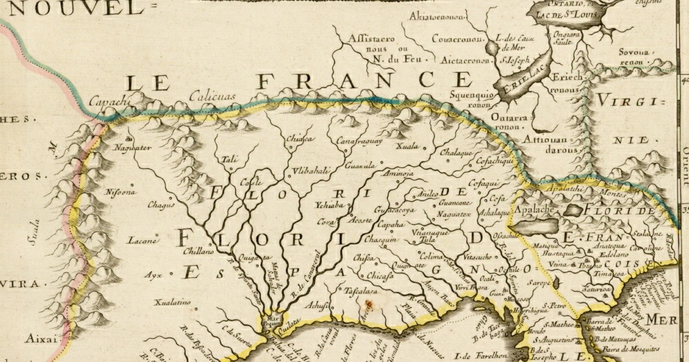
This notion of a great east-west mountain range running from Georgia to New Mexico was continued into the middle of the following century, principally by the leading cartographer of the day, Nicolas Sanson.
This map makes graphic one of the most important consequences of this belief, the topographical impossibility of a very large and long river emptying into the Gulf of Mexico from the central part of the continent, even though by the middle of the sixteenth century there had been numerous reports of the size of the Mississippi, beginning with the De Soto expedition. Sanson and other cartographers tried to get around this by having numerous shorter rivers joining together to form a large river near the gulf, but the mythical mountain range prevented mapmakers from showing the very real Mississippi River.

The southern Mississippi River had been discovered by De Soto in 1541, with its northern parts first heard of by the French in the Great Lakes region in the early seventeenth century. In 1673, Jolliet and Marquette sailed as far south as the Arkansas River before turning back, and La Salle also explored the northern part of the Mississippi a few years later. Both parties deduced that the river flowed directly south into the Gulf, though this was not yet proved.
In 1683, a map by Louis Hennepin showed the upper part of the Mississippi with a dotted line extending south. Note that Hennepin does not show any orography in North America, thus neatly side-stepping the issue of the mountain range other maps showed blocking the projected course of the Mississippi.
In 1682, La Salle continued his exploration of the Mississippi, this time sailing all the way down to the river’s mouth at the Gulf of Mexico, proving that the river was long as well as wide. However, for a number of reasons, including the idea that there were mountains running east-west across the continent, the mouth of the Mississippi was placed too far west, as shown on the 1691 Le Clercq map of North America. This became the dominant picture of the Mississippi’s course for the rest of the century.
Not all cartographers followed this, as for instance the Robert Morden maps of 1688 showed the mouth of the Mississippi in the correct location, but note how he has the mountains running right up to the river.
It wasn’t until 1703, with Guillaume Delisle’s “Carte du Mexique et de la Floride,” that the Mississippi was firmly placed in its proper course. Delisle was the leading French cartographer of the day and so he had access to the best material of the French explorers in North America. This map was based on reports from many of those explorers, including survivors of the La Salle expedition.
Delisle shows the Mississippi flowing in essentially its correct course, dealing with the east-west mountain range issue by removing it from the map completely.
He did include that mythical range on his 1718 map of North America, though like Morden, he simply stopped it at the Mississippi. This range made an appearance on a few subsequent maps, but generally the western extend moved further and further east until the cartographic picture of the southern Appalachian mountains matched reality.