Showing posts with label Mythical. Show all posts

Wednesday, May 27, 2020

Whirlpool at the North Pole

In 1569, the great Flemish cartographer, Gerard Mercator, issued this important world map—-the first to use the so-called Mercator projection—-and on that map he introduced a radical and strange notion of the geography around the North Pole. Along the very top of the map-—the width of which is exaggerated because of the projection used-—are four bodies of land with rivers running between them.


This geography was clarified by an inset in the lower left, in which you can see four islands surrounding the North Pole, upon which lies a large rock.


It is a little easier to see this geography on Mercator's separate map of the North Pole issued a number of years later. A legend on the earlier map states that Mercator got his geography of the Arctic from the report of a Friar and mathematician from Oxford, who supposedly in about 1360, and using “magic arts,” went to these polar islands and mapped them. Mercator’s source of this story was a since lost, fourteenth-century account called the Inventio Fortunatae.


Describing the geography of the polar region, Mercator wrote to John Dee, an English scholar and mystic, that “In the midst of the four countries [that is islands] is a Whirl-pool...into which there empty the four Indrawing Seas which divide the North. And the water rushes round and descends into the earth just as if one were pouring it through a filter funnel...Except that right under the Pole there lies a bare rock in the midst of the Sea. Its circumference is almost 33 French miles, and it is all of magnetic stone...”


Mercator shows this geography very clearly, with the four islands separated by the rivers and the large magnetic rock sitting on the pole itself, over the whirlpool where the waters descend into the interior of the globe. Other bits of information depicted by Mercator, also taken from the Inventio, include the legend that “pygmies, whose length is four feet” live on the island above Scandinavia, and another legend on the island to its left, stating it is “the best and most salubrious in all the north.”


Obviously, this is mythical geography, though the Inventio Fortunatae may have been based to some extent on first-hand reports by Ivar Bardarson, who was a priest from Greenland who traveled widely in the eastern Canadian Arctic in the early fourteenth century. Whether the story of the waters of the world passing through four rivers and then into the whirlpool was a confused misreading of Bardarson’s reports, or an illusionary creation of the Inventio’s author cannot be known.


The Mercator conception was followed by a number of other late sixteenth century cartographers, such as in the world map by Abraham Ortelius from 1570.


However, this misconception did not hang around for long. The latter half of the sixteenth century was a time of considerable exploration in the waters north of Europe, for instance by Hugh Willoughby in 1553 and Willem Barentz in the 1590s, and Mercator’s polar geography of the four islands and the whirlpool began to lose favor, as shown in Barentz’s own map of the polar region from 1598. This geographical myth subsequently did not last long, and it had disappeared from most maps by the fourth decade of the seventeenth century.


[Click here to see on-line lecture on this myth
and the myth of the great continent at the South Pole.
]


Monday, October 16, 2017

MOUNTAINS ACROSS THE COUNTRY

It has been a while since I’ve written about mythical geography, so today I’m going to look at a myth which appeared in the mid-sixteenth century and which lasted for about a century and a half, that is, the geographic error of showing a mountain range running east to west across the southern part of today’s United States.


This myth had its origins in the reports of the explorations of Hernando De Soto. De Soto was the governor of Cuba and was given a license by the Spanish King to explore “Florida,” which was the name applied to the essentially unknown land north of Cuba which had been discovered by Ponce de León in 1513. De Soto set sail in May, 1539, landing in today’s Tampa Bay with 600 men. He explored to the north and then west, discovering the Mississippi River in May 1541. De Soto died the following year, with the survivors of his expedition sailing down the Mississippi and then along the coast to Spanish settlements in today’s Mexico.


De Soto had set off to the north from the Gulf until he ran into the Appalachian mountains in the area where today's North and South Carolina and Georgia meet. The expedition then marched in a west-southwest direction, following the foothills and this seems to have led to the conception of a range of mountains running across the continent east to west.

This concept is graphically shown in a map probably drawn about 1544 by the Spanish royal cartographer, Alonzo de Santa Cruz, based on reports by the survivors of the De Soto expedition.


This notion soon made it to the general map publishing world, for instance in a 1562 map by Diego Gutiérrez, though he does seem to just scatter a whole series of mountains in North America under the large royal crest.


The east-west mountain range is even more strongly shown on Gerard Mercator’s important 1569 world map, one of the most influential maps of the sixteenth century, as well as graphically on Cornelis de Jode’s “Americae Pars Borealis” [Northern part of America] from 1593.


This notion of a great east-west mountain range running from Georgia to New Mexico was continued into the middle of the following century, principally by the leading cartographer of the day, Nicolas Sanson.

This map makes graphic one of the most important consequences of this belief, the topographical impossibility of a very large and long river emptying into the Gulf of Mexico from the central part of the continent, even though by the middle of the sixteenth century there had been numerous reports of the size of the Mississippi, beginning with the De Soto expedition. Sanson and other cartographers tried to get around this by having numerous shorter rivers joining together to form a large river near the gulf, but the mythical mountain range prevented mapmakers from showing the very real Mississippi River.


The southern Mississippi River had been discovered by De Soto in 1541, with its northern parts first heard of by the French in the Great Lakes region in the early seventeenth century. In 1673, Jolliet and Marquette sailed as far south as the Arkansas River before turning back, and La Salle also explored the northern part of the Mississippi a few years later. Both parties deduced that the river flowed directly south into the Gulf, though this was not yet proved.


In 1683, a map by Louis Hennepin showed the upper part of the Mississippi with a dotted line extending south. Note that Hennepin does not show any orography in North America, thus neatly side-stepping the issue of the mountain range other maps showed blocking the projected course of the Mississippi.


In 1682, La Salle continued his exploration of the Mississippi, this time sailing all the way down to the river’s mouth at the Gulf of Mexico, proving that the river was long as well as wide. However, for a number of reasons, including the idea that there were mountains running east-west across the continent, the mouth of the Mississippi was placed too far west, as shown on the 1691 Le Clercq map of North America. This became the dominant picture of the Mississippi’s course for the rest of the century.


Not all cartographers followed this, as for instance the Robert Morden maps of 1688 showed the mouth of the Mississippi in the correct location, but note how he has the mountains running right up to the river.


It wasn’t until 1703, with Guillaume Delisle’s “Carte du Mexique et de la Floride,” that the Mississippi was firmly placed in its proper course. Delisle was the leading French cartographer of the day and so he had access to the best material of the French explorers in North America. This map was based on reports from many of those explorers, including survivors of the La Salle expedition.


Delisle shows the Mississippi flowing in essentially its correct course, dealing with the east-west mountain range issue by removing it from the map completely.


He did include that mythical range on his 1718 map of North America, though like Morden, he simply stopped it at the Mississippi. This range made an appearance on a few subsequent maps, but generally the western extend moved further and further east until the cartographic picture of the southern Appalachian mountains matched reality.


Thursday, May 11, 2017

The Vérendryes search for a route to the Pacific Ocean

As discussed in the previous blog, the French were very focused on finding a "River of the West", which would provide a water route from the western part of New France to the Pacific Ocean. The search for it became the obsession of a family of French trappers, the patriarch of which was Pierre Gaultier de la Varennes, Le Sieur de la Vérendrye. At his post at Thunder Bay on Lake Superior, Pierre Vérendrye heard from Native Americans of a great river which would lead to the Pacific, and with backing from French Canadian merchants, he and his sons built a series of trading posts to the northwest of Lake Superior as bases from which they could explore for this hoped-for river.


Vérendrye’s initial information on this river came from some maps of the region west of Lake Superior he was given by local Indians, including by a Cree named Auchagach in 1728. Auchagach’s maps showed the system of rivers and lakes which flowed into Lake Superior from the northwest, which were shown as arising in a “River of the West” which started near some Mountains of the Bright Stones, flowed into Lake Winnipegosis and then on to the Lake of the Woods. Vérendrye had Auchagach’s maps copied in manuscript, and one of those was copied by Bellin onto his map of North America from 1743.


Auchagach’s maps were, of their type, quite good, but by the time his water system made it onto Bellin’s map, it was far from reality. Auchagach’s maps had neither orientation nor scale indicated and Bellin erred in both these aspects when he copied them to his map. The actual river systems to the northwest of Lake Superior have a much more Northwest-Southeast orientation than the almost straight West-to-East alignment shown by Bellin, and Bellin shows the river systems as much larger than they are in reality. While Bellin does not show a definite Pacific coast in the west, his River of the West extends very close to wherever that coast would be, presenting what appears to be an easy water route to the Pacific. As good as this looked on Bellin's map, failed French attempts in pursuing this route to the Pacific in the following years soon demonstrated the fallacy of Bellin’s depiction.


The Vérendrye family influence on the story of the River of the West, however, extended further than this. In 1738, continuing to look for a water route to the Pacific, the Vérendryes traveled west from Lake Winnipeg along the Assiniboine River, then dropped south into what is today North Dakota. There they came to a village of a tribe they called the Mantannes. The sons then visited a village further on which they said was located on the “Riviere des Mantannes.” About this river Pierre later wrote:
“I discovered recently a river flowing to the west... That the river appeared to go, according to the compass, south west by south...the lower part may go to the sea to the south west by west.”
That is, the river may flow to the Pacific Ocean.


According to a scholarly study, the Vérendrye sons had probably visited a Hidatsa village [though the names are similar, the Mantannes were almost certainly not Mandans, as they are often thought to be]. The village was located just south of the conjunction of the Little Knife River with the Missouri, on a part of the Missouri where it looks like the river flows south/southwest. The perceived direction of the river flow, combined with information gathered from conversations with the Indians interpreted through the lens of their hopes, led the Vérendryes to conclude the river might be the much desired River of the West. Philippe Buache included his take on their "discovery" in his 1754 map of western New France shown above.


Interestingly, though by the time it was issued, Buache included another version of Auchagach's map in a panel at the top of the map. This is similar to the one shown on Bellin's map, but by 1754 it was not something that was generally believed by the French.


In the main part of the map, Buache shows his take on the Vérendryes' discoveries. The Assiniboine River is shown flowing east-west below Lake Winnipeg, and along its side is a trail labeled as ‘warrior’s route to the River of the West.’ This path crosses a ridge of mountains and comes to an “Ouachipouanes” village (the Cree name for the Mandan), which is located on a river which shortly makes a large bend to the west. Soon after it turns west, this river becomes a dotted line labeled “Riv. de l’Ouest.”


Buache tried to merge this Vérendrye information with previous beliefs, so he has another river, which flows out of a "L. du Brochet," merge with the dotted-line River of the West [this coming from Delisle's 1722 map shown in the previous blog] and this river in turn flows into our old friend the Sea of the West.


By the middle of the century, the Vérendryes seem to have discounted the idea that the River of the Mantannes was a true “river of the west,” but that river did hang around on maps for a number of years, sometimes shown as flowing to the west and sometimes depicted as possibly being connected with the Missouri, as on this Bellin map from 1755. Here Bellin shows a "Riv des Manton" connected with a lake similar to Delisle's Brochet Lake, but without a clear indication of whether that river flows east or west. Belling includes a note by the river which indicates that the river might be the source of the Missouri. Bellin didn't commit one way or the other to the River of the West, also including a note by the Assiniboine River indicating it might lead to the River of the West.


Basically, the French were still confused, not sure if there was a Sea of the West, River of the West, or some other water route to take them from the Great Lakes to the Pacific. Unfortunately for them, they were never able to figure it out, for as a result of the French & Indian War, in 1763, they gave up all their possessions in New France to the British.


Tuesday, April 18, 2017

The French seek a route to the Western Sea: 1700-1722

Guillaume Delisle’s map of North America from 1700 left the area to the west of the Great Lakes blank, demonstrating that the French really didn’t know what was going on in that region. However, this doesn’t mean that there weren’t theories of what might be there, including some considered by Delisle himself.


Sea of the West


From 1695 to about 1700, Guilluame and his father Claude drew a series of manuscript maps of that region which include a large “Mer de l’Ouest,” that is, a “Sea of the West.” This Sea of the West is a distant cousin of the Sea of Verrazano, though as Delisle noted it was based on a number of Indian reports recorded by the French in the second half of the seventeenth century. A viable path to the Pacific had been a focus of the French from the beginning of New France, so they were always questioning Indians they met about possible water routes to the west. Communication was, of course, imperfect, and probably neither party really understood what the other said, with the French always interpreting what they heard in light of their pre-existing notions.


The French understood the Indians tales as indicating that there was a large body of water not too far to the west, which could be reached by river and which would provide access to the Pacific. In the Jesuit Relations of 1659-60 there is the report of a sea lying just ten days journey to the westward of the Great Lakes, and this sea was mentioned in other Indian reports recorded in the Relations in the following years. These reports claimed that the Indians mentioned various characteristics of this sea—-such as having tides and with Europeans living along it—-which indicated that the sea was connected to the Pacific.


Later in the century, French explorers in the western parts of New France heard similar tales. For instance, in 1685 Daniel Greyselon, Sieur Duluth reported hearing from some Indians “that it was only twenty days’ journey from where they were to the discovery of the great lake whose water is not good to drink,” that is a lake of salt water. In 1688, Jacques de Noyon explored the river systems to the northwest of Lake Superior meeting some Assiniboines who, when he enquired about the Western Sea, told him they would take him in the spring to that sea, upon which there was a great city with walls of stone and a race of men who were white and bearded. Noyon did travel with the Indians as far as Lake of the Woods, and there they told him that a river flowed from that lake into the Western Sea.


Besides all these Indian and explorer reports, the possibility of a Sea of the West was supported by a 1625 story by one Juan de Fuca, who said that in 1592 he been sent by the Viceroy of New Spain north along the California coast searching for the “Strait of Anian,” which was the supposed entrance to the passage across the north of America from the Pacific Ocean. Fuca said at between 47 and 48 degrees north he found a bay which he sailed into, thereafter finding a large sea which led further to the east. After sailing for more than twenty days, Fuca thought that he had reached the “North Sea” (that is the Atlantic), thus achieving what he had been sent to do.


Whether Fuca’s tale was a complete fabrication or a confused account of an actual voyage has never been determined for certain. However, there are no archival records of such a voyage, and there is no knowledge of a Spanish ship ever having reached beyond 43° N in that period. Whatever the truth of this tale, it was another “first-hand” account which seemed to indicate the possibility of a large sea to the west of the Great Lakes.


The Fuca tale, along with the Indian & explorer reports enthused the French so much that near the end of the sixteenth century the governor and intendant of New France recommended to the King that they establish posts in the western part of the colony as bases from which to explore for the Western Sea. The Fuca tale, along with the Indian and explorer reports, also stimulated Claude and Guillaume Delisle to consider the possibility of a Sea of the West.


Like all French geographers, they were trying to figure out what was going on beyond New France. By the late sixteenth century, they had a better idea of the width of the continent, so the closeness of the sea mentioned in the Jesuit Relations seemed to give support to the notion that there was an arm of the Pacific extending into the continent. Based on all of this, between 1695 and 1700 the Delisles drew a number of manuscript maps showing a Sea of the West lying between the Great Lakes and the northern coast of California. Interestingly, they must have had doubts about this sea, for it appears on none of Guillaume’s printed maps.


Delisle’s Sea of the West did, however, find a believer in another French cartographer, Jean Baptiste Nolin, who in 1700 produced a double hemisphere world map showing this sea in a form essentially similar to Delisle’s. Delisle claimed that Nolin copied his geography from a manuscript globe he had produced for the Chancellor of France, which did show the Sea of the West. Delisle won his suit in 1706, which forced Nolin to remove any of the “offending geography” from all his coppers plates and also to destroy all copies of the wall map in existence (resulting in the fact that only three copies on the Nolin map are known to have survived).


However, the Nolin map had already been copied by Dutch publishers Pierre & David Mortier, and their world map included the Sea of the West depiction. This map was beyond the reach of the French courts so it was circulated in Europe, giving wide distribution to the Sea of the West notion. Besides this, Nolin produced other maps with a smaller, modified Sea of the West, and by these means this non-existent geographic feature appeared on a number of maps in the first half of the eighteenth century.


Long River


About the same time as the mythical Sea of the West first appeared, another non-existent body of water was introduced to the geography west of the Mississippi River, this time probably based more on a deliberate falsehood than on mistaken interpretations of Indian reports.


This new myth was of a “Riviére Longue,” perpetrated by Baron Louis de la Hontan. As an officer in the French military, in 1683 Lahontan went to New France and traveled extensively throughout the colony. In 1703, he wrote about his travels in Noueaux Voyages de M. le Baron de Lahontan dans l’Amerique Septentrionale. In that work, Lahontan claimed that during a six month period in 1688, he explored from the Great Lakes to the Mississippi River, going as far south as the Missouri River, then heading north along the Mississippi until he came to this Long River.


Lahontan recounted how there he met a tribe of Mozeemlek Indians, who told him that the Long River arose in some mountains well to the west, and that on the other side of those mountains lay another river flowing westward, which is where they had their home. Furthermore, Lahontan recorded that the Indians stated that that river flowed about 500 miles to the west where it emptied into a great salt lake, about 300 leagues (1,000 miles) in circumference. This geography was boldly illustrated on this map published in the Nouveaux Voyages.


While Lahontan did travel around New France, the consensus is that his tale of the Long River and his meeting with the Mozeemlek was made up. Though it is possible that this episode did occur, in which case the Long River was probably the Missouri, the geography presented in the map is very mistaken. However, a ‘first hand’ report from someone who had explored in the region was not to be dismissed lightly, and Lahontan’s Long River appeared on a number of maps, such as Guillaume Delisle’s Carte du Canada [1703] and Gerard Van Keulen’s Carte de la Nouvelle France [1720].


While the River Long soon passed from the scene—-Delisle never again showed this river--the notion of a river flowing into the Mississippi with its source in some mountains to the west, over which lay a westward flowing river—-a notion introduced by Marquette in the previous century (see previous blog to read about this)—-which emptied into a salt lake or sea, was reinforced by Lahontan’s imaginary geography.


In the beginning of the 18th century, the search for the Western Sea became an important focus for the the French. In 1717, the French Council of the Marine wrote that:

“If the Western sea is discovered, France and the Colony could derive great benefits in trade,... The navigation would be brief, compared with European vessels and subject to far fewer risks and costs, which would provide such great benefit over the trade of that country that no European nation could compete with us.”
The Governor and Intendant of New France recommended to the King that a number of posts be established to the west of the Great Lakes as bases for the search for the Sea, and in 1720, Father Charlevoix was sent out “to proceed to the principal posts of the upper country in order to make inquiries there respecting the Western Sea.”


About this time, Father Bobé presented to the King a “Memoir for the Discovery of the Western Sea,” in which he argued that this shouldn’t be a difficult search, for the Western Sea was not far distant from New France and could be reached by a number of feasible routes. He thought that the suggested route up the Missouri then across the mountains to a western flowing river provided an easy route, though it was possible the westward flowing river might end up in the Bay of California rather than the Western Sea. Also feasible was a practical portage west from the headwaters of the Mississippi to a westward flowing river which would empty into the Western Sea.


These concepts are shown nicely in our old friend Guillaume Delisle’s map of 1722, which shows a “Grande Rivier coolant a l’Ouest,” probably the first mention specifically of a “River of the West,” which would soon take center stage in the search for the waterway to the Pacific.


[ Go to previous blog about the quest to find a water route to the west ]


Click here to read the next stage in the search for a route to the Pacific.


Friday, March 10, 2017

The French seek a route to the Western Sea: to 1700

From the time of Columbus, finding a practical sea route to China and the Indies was very much a goal for the major European powers, including France. In the first decades of the sixteenth century, the Spanish had claimed most of the lands between Florida and the northern part of South America, and the French hoped to find a route to the Orient by sailing north of those Spanish domains. Thus King Francis sent out Giovanni da Verrazano to explore that region, looking for the desired sea route to the South Sea, as the Pacific Ocean was then known.


From March to June, 1524, Verrazano sailed from the northern part of today’s Florida to Newfoundland, making many discoveries, such as New York and Narragansett Bays. The ships of the day could not point close to the wind, so Verrazano could not sail right up the coast, but had to beat out to sea and then back in towards land, meaning he saw only a series of discontinuous sections of the North American coast. This explains why Verrazano missed discovering both the Chesapeake and Delaware bays.


Early in this voyage of discovery, Verrazano came upon one of the barrier islands of North Carolina. He did not see any of the gaps between the islands, but did see what looked to be a vast body of water across what he took to be an isthmus of land. As the whole point of his exploration was to find a route past the Americas, the Pacific Ocean was very much in the front of Verrazano’s mind, and thus he jumped to the conclusion that that body of water was the Pacific. As he wrote in a letter to King Francis:

We called it Annunciato from the day of arrival, where was found an isthmus a mile in width and about 200 long, in which from the ship, was seen the oriental sea between the west [corrected from ‘east’ in the text] and north. Which is the one, without doubt, which goes about the extremity of India, China and Cathay. We navigated along the said isthmus with the continual hope of finding some strait or true promontory at which the land would end toward the north in order to be able to penetrate to those blessed shores of Cathay.”


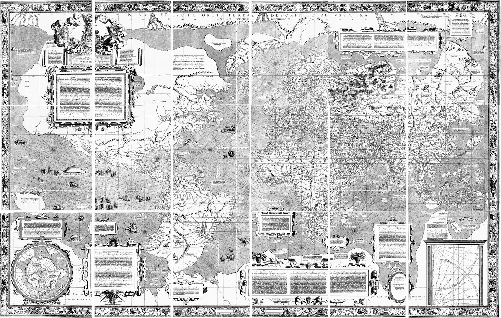
As a result of Verrazano’s report, this concept—-that somewhere along today’s American southeastern coast, there was an arm of the Pacific Ocean separated from the Atlantic only by a narrow isthmus—entered into the European understanding of the region, for what better source could there be than a first-hand report? This hypothesis was reinforced by a manuscript map drawn by Verrazano’s brother, Girolamo, which showing this “Sea of Verrazano” in graphic fashion. This false sea was soon shown on other maps, like Lok's 1582 map shown above.


About a decade later, the French tried again. Jacques Cartier was sent out to seek the passage to the Pacific in the regions to the north of Verrazano’s route. In two voyages between 1534 and 1536, Cartier discovered the Gulf and River of St. Lawrence, sailing as far west as an Indian village, Hochelaga, located where Montreal is today. The local Indians told him of large bodies of water to the west, and Cartier was convinced that if he could have kept sailing he would have reached China and the Indies.


By the end of the sixteenth century, most European geographers had rejected the idea of a large Sea of Verrazano lying across the middle of the North American continent, so the general consensus was that the two most likely possibilities for a water route west from Europe to China and the Indies were either by a “Northwestern Passage” around the northern coast of America, or by a route which began with the St. Lawrence River. It wasn’t clear to geographers if that route would end up in the supposed North Sea or would lead right across the middle of the continent to a “Western Sea.” This Western Sea would, of course, either be the same as or would lead to the Pacific Ocean.


Samuel de Champlain became a believer in the latter of these routes. He began visiting Canada in 1603 and over the following years explored further into the interior, where, like Cartier, he heard of large bodies of water to the west. He is reported to have promised “never to cease his efforts until he has found either a western sea or a northern sea, opening the route to China, which so many have thus far sought in vain.” (Lescarbot, La Nouvelle France, 1609). Champlain did discover two of the Great Lakes-—Huron and Ontario—-but no western or northern sea. Still, he remained convinced that a route to the Pacific lay somewhere up the greater St. Lawrence water system.


This was a widely held belief at that time, and in particular it had become the “ever-constant opinion of a school of contemporary geographers, that the great river of Canada [St. Lawrence] issued from a lake which also poured its waters by another channel to the South Sea.” (Justin Winsor, Cartier to Frontenac, p. 99) That is, the thought was that if one went far enough up the St. Lawrence, one would come to a lake which not only was the source of the St. Lawrence, but also of a river which flowed westward to the Pacific.


In the early seventeenth century, French explorers and missionaries continued to make inroads in exploring the Great Lakes and the river systems feeding the St. Lawrence. At some point the French heard of a “Nation of Stinkards,” who came from a body of water which smelled foul and which rose up and down. This sounded to the French an awful lot like the Western Sea they were seeking, bringing them, they hoped, into contact with traders from Cathay.


In 1634, Jean Nicolet was sent to find these “People of the Sea,” sailing from Lake Huron into Lake Michigan and on to Green Bay, wearing a damask robe for his anticipated contact with the Chinese. While he didn’t find the Western Sea, he was convinced that he would have found it if he had been able to sail just three more days journey up a river which flowed into Green Bay. His belief in this may have come from rumors he heard about the Mississippi River, which one could get to by sailing up the Fox River, which flows into the southern end of Green Bay, then down the Wisconsin River, with only a short portage between them.


The Mississippi seems to have been the source of a number of tales, reported in the Jesuit Relations, which the French missionaries heard from the Indians in the following decades about a large river which lay to the west of Lake Superior. This river supposedly lay not too great a distance west of the Great Lakes, maybe eight days journey, though the distances varied. The French understood these tales as indicating that this river flowed into a salt water sea where could be found men who were like the French. While it is possible that there might have been some reports, which traveled along the Mississippi River, of contacts with the Spanish on the Gulf of Mexico, it is more likely that these reports came from a wishful-thinking misinterpretation of reports provided by eager-to-please Indians.


The French hoped that this river was their long-sought-for route to the Indies and China, but they were not sure which direction it would take them. They thought that it could lead north to a “Mer Glaciale,” which they believed might lie west of Hudson’s Bay, connecting to the Pacific. They also thought the river could lead southwesterly, either to the Gulf of Mexico-—to which of course the Mississippi does lead—-or to the “Vermillion Sea,” which was at that time thought to be a sea lying between the North American coast and the large island of California. Finally, it was also thought possible that this was a “River of the West,” which would flow directly west to reach the Western Sea.


By 1669, the French had received clearer reports of the “Messipi” River, which flowed southward. They hoped it would flow to the Vermillion Sea, thus offering them a route to the Orient. Thus, Louis Jolliet and Father Jacques Marquette were sent out in 1673 to explore the river and see where it went. Jolliet and Marquette canoed down the Mississippi to its confluence with Arkansas River, at which point they realized it likely flowed into the Gulf of Mexico, and so they turned back.


All was not lost, however, for when they passed by the mouth of the Missouri River, flowing into the Mississippi from the west, the explorers thought that this might be the real route to the Western Sea. The Relation of 1672-73 (written by Father Dablon) gives this account from Marquette

“Pekitanoui (as they named the Missouri) is a river of considerable size coming from the Northwest from a great distance and it discharges into the Mississippi; there are many villages of savages along this river and I hope by its means to discover the Vermilion or California Sea....It would be a great advantage to find the river leading to the southern sea toward California and as I have said this is what I hope to do by means of the Pekitanoui according to the reports made to me by the savages. From them I have learned that by ascending this river for 5 or 6 days one reaches a fine prairie 20 or 30 leagues long. This must be crossed in a Northwesterly direction and it terminates in another small river---one which one may embark for it is not very difficult to transport canoes through so fine a country as that prairie. This second river flows toward the Southwest for 10 or 15 leagues after which hit enters a lake, small and deep. [That lake is] The source of another deep river which flows toward the west where it falls into the sea. I have hardly any doubt that it is the Vermilion Sea and I do not despair of discovering it some day.” (Vol. 59, p. 143)


This concept was confirmed by Louis Hennepin, who in 1680 was sent by La Salle down the Illinois River to the Mississippi River. On his trip Hennepin saw the Missouri, about which he wrote, in 1683, that the Indians informed him that “its source was found by ascending ten or twelve days journey to a mountain from which all these streams are seen flowing, that then form this river. They added that beyond this mountain the sea is seen and great vessels....” (From Louis Hennepin, A descripton of Louisiana. New York: John G. Shea, 1880, p. 344) In a book published in 1697, which expanded on his 1683 publication—much of the expansion being fabrication—Hennepin expanded on this with the assertion: “They told me further than from that Mountain [emphasis added] one might see the Sea, and now and then some great Ships..” (From English edition A New Discovery of a Large Country in America by Father Lewis Hennepin, 1698).


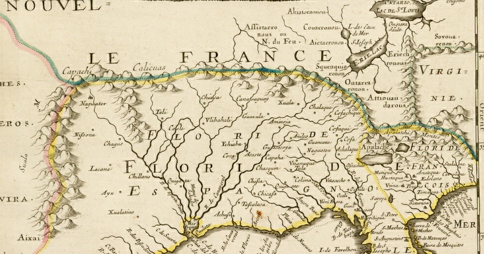
These reports of Marquette and Hennepin seemed to offer a plausible water route to Pacific, as was first demonstrated in a 1691 map by Chrestien Le Clercq. The Missouri River is there shown as arising in some mountains, from which also flows a river which leads to the Vermillion Sea.


The general acceptance of this notion by many French geographers at the end of the century is further demonstrated in a 1700 map by Guillaume Delisle, a leading French cartographer of the day who became Premier Géographe du Roi in 1718. On that map, the Missouri (“Pekitanoni R.”) is shown arising-—though somewhat speculatively, as Delisle uses dashed lines for part of its course—-in the R. des Francisco and S. Jerome, whose headwaters again lie not very far from the “R. de bon guis,” that is the Colorado River, which flows to the Gulf of California.


By that time, hope in a route to Cathay by heading to the north of the Great Lakes had faded both because of the lack of success in finding any western outlet from Hudson’s Bay or other northern waters, and also because by then the British had seized control of the area to the north with their Hudson’s Bay Company, founded in 1670.


As for the third alternative, a sea route heading west from the Great Lakes, there was no clear evidence, though there were suggestive reports. Whether such a route existed simply was not known, as Delisle shows by leaving the area west of the Great Lakes totally blank. Most maps had left this area blank, and making this a convenient place to put cartouches and inset maps—a common thing demonstrated in the Delisle map. Of course, it is such blank spaces on maps that allowed for continued, unfettered speculation, and this is exactly what we will find in the following decades. It is just in this hitherto blank area to the west of the Great Lakes that myriad conjectures about water routes to the Western Sea would appear in the eighteenth century.


[Go to next blog in this series ]
[ Go to previous blog in this series ]


Wednesday, February 15, 2017

John Dee's Fantastic Map of 1582

John Dee (1527-1608) was an English alchemist, astrologer, astronomer, mathematician, and practitioner of the occult arts. He lived at a time when the occult and science were just beginning to be separated and Dee had a foot firmly planted in both worlds, being an expert in both arcane and scientific knowledge.


His erudite and wide-ranging abilities gave him a prominent place in Elizabethan England; he served periodically as Queen Elizabeth’s advisor and tutor, and he was well connected with, among others, William Cecil, Sir Philip Sidney, Robert Dudley, and Sir Humphrey Gilbert.


In the 1570s, the Elizabethans had turned their eyes to the lands and seas west of the British Isles. Martin Frobisher was seeking a passage around the norther end of North America—-the famous Northwest Passage-—and Sir Humphrey Gilbert was applying for letters patent to colonize the continent north of the Spanish in Florida, which he received on June 11, 1578. Dee was an important figure in the world of Tudor geography.


For an extended period, from about 1551 to 1583, Dee was an advisor for English voyages of discovery, to the Northeast and to the Northwest, including for the Muscovy Company. He helped to instruct a number of notable English captains, including Richard Chancellor, Stephen and William Borough, Martin Frobisher, Humphrey Gilbert, John Davis, and Walter Raleigh, and he may have been an advisor for Drake's voyage around the world. His 1577 Perfect Arte of Navigation (more a geography and propaganda for the English empire than a science of navigation) was originally intended as part of a larger work, a general history of discoveries.


Interestingly, Dee actually coined the term “British Empire,” though in his case “British” referred to the earlier inhabitants of the islands, for he argued that the mythical Prince Madoc had discovered North America, establishing first rights to the continent for the English.


Dee was also a cartographer, having studied with the great Gerard Mercator. He drew a number of manuscript maps, including one of the North America in 1580 for Queen Elizabeth. About 1582, he prepared a map of the northern hemisphere with a polar projection for Humphrey Gilbert (shown above). His depiction of the North Pole was based on Mercator’s map of that region, about which Mercator had written to Dee in 1577, explaining his sources. The rest of the map seems to be drawn for propaganda purposes, promoting various possible ways to sail to “Cathaia,” which is shown opposite Great Britain. The map depicts various open waterways to the East, including routes north of both Scandinavia and Russia, and North America.


The most extraordinary part of the map, clearly demonstrating Dee’s fixation on water routes, is the rendering of North America, which is a veritable Swiss cheese of rivers and lakes. Dee shows the Sea of Verrazano, approaching very close to the Atlantic in the region of Virginia, but there are also numerous other waterways interlacing the continent. He shows a very early version of a non-existent lake in the southeast, with a river flowing into the Atlantic, with two other rivers entering this lake on its western shore: one connecting the lake with the Gulf of Mexico and one flowing all the way from northern Mexico. To the north of the Sea of Verrazano flows the St. Lawrence, a branch of which connects to that sea and another of which flows to a large gulf on the northern coastline of the continent.


To the west of Hochelaga (where Montreal is today) is a large lake, out of the west of which a river extends to the northern end of the Gulf of California. Interestingly, another river extends from the Gulf of California to the northwest, while a river on the northwest coast of America flows to the east past the mythical city of Quivira, reaching toward, but not quite meeting the other river. Whether these rivers actually meet is left somewhat vague, perhaps Dee hinting at the notion of California as an island, which wouldn’t be definitely shown on maps for another four decades.


Dee’s map shows the geographic notions floating around England at the end of the sixteenth century. Part of the reason they wanted to settle North America was to have a base for the believed-to-exist route to the Pacific, and looking at this map this makes a lot of sense. Of course, they were quite wrong and it wasn’t too long before the English focused most of their attention on the search for the Northwest Territory. However, the concept of a more southerly water route across the continent did not die for several centuries yet, next being taken up by the French and their search for a ‘River of the West.’


[ Go to next blog in this series ]
[ Go to previous blog in this series ]