Tuesday, December 4, 2012

Maps in movies

Over the weekend I watched the 2002 version of the movie Solaris, which though I am a Sci Fi fan was not my favorite example of that genre. Be that as it may, it did have a map in the background of one of the scenes. This is a scene with Chris Kelvin (George Clooney) and Rheya (Natascha McElhone) in the kitchen of Chris' apartment. If you look closely, in the background is a 19th century map (Johnson?) of Illinois.


The map is rather fuzzy and I am not sure why this map is there. Maybe the apartment is supposed to be in Chicago or perhaps it was a map that belongs to the actual owner of the apartment used for the scene (assuming it was not a kitchen built on a set). In any case, not terribly exciting, but still I do enjoy finding maps in movies even if they do not play much of a role.


Maps also appear in this year's movie Lincoln, but there they play a larger role. This was called to my attention by Susan Schulten in her map blog. As Susan points out, in this movie the maps used are displayed as an important part of the on-going drama.


As Susan describes in her excellent book, Mapping the Nation (discussed in an earlier post in my blog), the Coastal Survey map of slavery in the southern US was an important document in Lincoln's thinking about the Emancipation Proclamation. [You can also read about this in an on-line paper by Susan.] Beyond this, however, maps were very much a part of the political landscape in Washington during the Civil War and this is nicely illustrated by their use in this movie.


Thanks to Susan for blogging on these maps and if you are interested in maps, you should take a look. Also, I hope anyone else who sees maps (or old prints for that matter) in movies will let me know.


Thursday, November 8, 2012

Alexander Wilson and John James Audubon

I have written a couple blogs about the history of Alexander Wilson and of his important work, American Ornithology. There is a very interesting part of the story of Alexander Wilson I have not yet discussed, and which mostly took place after Wilson's death, viz. a rather fierce feud that arose between a group of Wilson supporters and those of John James Audubon.


It has been suggested that this feud started as a conflict that arose between Wilson and Audubon themselves, during the meeting of the two in Louisville in 1810, mentioned in my first Wilson blog. However, this is unlikely. First off, Audubon was not really a rival to Wilson at the time, and indeed it has been convincingly argued that Audubon was inspired to go ahead with publishing his own work because of his meeting with Wilson. Also, Wilson had several times met other artists/naturalists with whom he had good relationships and there was no reason he should have then felt threatened by Audubon. And finally, Audubon and Wilson went hunting together a couple days after they first met, apparently perfectly amiably.


This feud actually began a decade after Wilson’s death, in April 1824, when Audubon first came to Philadelphia looking for a publisher and financial support for his planned Birds of America. There Audubon ran into significant resistance to his plan, at the heart of which lay the fact that Alexander Wilson had become one of the revered figures in Philadelphia scientific circles and Audubon was seen by some as a threat to Wilson’s preeminence.


In Philadelphia, Audubon was introduced to Charles-Lucien Bonaparte, Napoleon’s nephew and a respected naturalist who had settled near Philadelphia. Bonaparte was very impressed with Audubon's work and said he would support Audubon if he could get Alexander Lawson to engrave the plates for the proposed book.


Lawson, however, was not at all impressed, saying that Audubon’s drawings were “ill-drawn, not true to nature and anatomically incorrect.” Bonaparte and Audubon tried to convince him, but Lawson replied “I think your paintings extraordinary for one who is self-taught—but we in Philadelphia are accustomed to seeing very correct drawings.”


Despite this reception, Bonaparte did not give up, so he took Audubon to a meeting of the Academy of Natural Science in hopes that he would find support there. Though there are no records of what specifically took place, it is clear that the meeting was a disaster for Audubon. The reaction of the members seems to indicate that Audubon tried to bolster the importance of his own work by criticizing Wilson’s, and this did not go over well at all. Audubon received no support and was later blackballed when he applied to membership of the Academy.


George Ord, who was vice president of the Academy at the time, defended Wilson and sharply criticized Audubon and his work, an approach Ord avidly continued to pursue thereafter. Ord attacked Audubon both as an artist/naturalist and as a man, claiming that Audubon was belittling Wilson.


From the reception he received, Audubon realized he would get no satisfaction in Philadelphia, the center of American natural science and publishing, so he would need to go to Europe to achieve the backing he was seeking. Of course, Audubon was successful in Britain and the first part of his magnificent Birds of America was issued in London just three years later. This was just the beginning of the feud between the Wilson and Audubon camps. In 1831, Audubon issued his Ornithological Biography, a book intended to accompany the prints from his Birds of America. In this volume, Audubon made the claim that when he and Wilson had met in Louisville, Wilson had borrowed a couple of Audubon’s drawings which he then used, unattributed, in American Ornithology.


Specifically Audubon mentioned the “Small-headed Flycatcher, about which he wrote.
“When Alexander Wilson visited me at Louisville, he found in my already large collection of drawings, a figure of the present species, which, being at that time unknown to him, he copied and afterwards published in his great work, but without acknowledging the privilege that had thus been granted to him. I have more than once regretted this, not by any means so much on my own account, as for the sake of one to whom we are so deeply indebted for his elucidation of our ornithology.


It is definitely true that the drawings are essentially the same. However, Wilson’s backers, led by George Orb, claimed that the copying went the other way. In his text, Wilson had written that the specimen he used for his drawing of the Small-headed Flycatcher was shot in April 1812 in New Jersey and Ord said he was with Wilson when it was shot. Wilson also claimed to have shot “several of the same species” and Lawson said that he made the engraving of this bird from an actual specimen.


Finally, Ord pointed out that there were other cases where Wilson definitely had drawn his images from life, but where Audubon’s drawings were so similar that he must have copied Wilson. A good example is the two depictions of the Mississippi Kite, which Wilson clearly had produced before Audubon's print.


In the case of the small-headed flycatcher it is not clear who copied whom and the debate continues to today. But what makes this story particularly interesting is that the only small-headed flycatchers anyone has ever seen are the ones in Wilson’s and Audubon’s prints! No such bird has been found today and while over the years some have claimed to have spotted this bird, no specimen has ever been brought forth. It would appear that one of these naturalist probably drew some variant of another known warbler or flycatcher, but no one is sure. A fun puzzle and story!

Thursday, October 18, 2012

Maps & the Kansas-Nebraska Act

I recently finished reading Susan Schulten’s fascinating Mapping the Nation. History and Cartography in Nineteenth-Century America. This scholarly work examines the development and importance of thematic maps in the United States during the 19th century. (The maps discussed in the books and an interesting blog by Susan can be found on the Mapping the Nation web site) One section that really caught my attention was the use of maps as part of the national argument over the Kansas-Nebraska Act of 1854 (pages 128-130).


In the previous blog, I discussed the Kansas-Nebraska Act as the most important change in the political borders of the trans-Mississippi West during the 1850s. It wasn’t just in political borders that this act had an impact, for it was one of the most controversial Congressional acts in an ante-bellum period filled with controversial acts.


The crux of the issue was, of course, slavery. In the Missouri Compromise of 1820, Congress laid down that slavery would not be permitted in the Louisiana Purchase lands north of 36°30” latitude. By the Kansas-Nebraska Act, however, these new territories would be created under the process of “popular sovereignty.” This allowed the citizens of Kansas and Nebraska—-despite the fact that both were north of the Missouri Compromise line—-to vote on whether to be free or slave.


To those opposed to the expansion of slavery, this was clearly a case of Congress stepping over the line drawn, not in the sand, but on the map. This caused a huge outcry in the north, led to the creation of the Republican party, and was one of the primary causes of the Civil War.


The issue was at its core a geographic one, so it is not surprising that maps played an important role in the furor over the Kansas-Nebraska Act. The act was introduced by Stephen Douglas on January 4, 1854, and within days a “large and influential meeting of citizens opposed to any violation of…the Missouri Compromise…” was held at the Broadway Tabernacle in New York City. Called “to protest against the project now pending in the Senate of the United States, for the repeal of that section of the Missouri Act which forever prohibits Slavery in the Territories lying north of 36 degrees and 30 minutes,” the meeting was attended by about 3,000 citizens.


Of great interest was a prop used for the meeting. As reported in a newspaper, “The front of the choir, in rear of the pulpit, was illuminated by a row of lights, intended to display the proportions of a large and handsome map of the United States and the Territories, prepared for the occasion by Mr. Colton. The map was painted upon white canvas and displayed the relative sizes and proportions of the States and Territories. A heavy black line was drawn entirely across its face, from the Atlantic to the Pacific, representing the latitude of 36°30’—-the line which defines the limitations imposed by the Missouri Act. The new Territory of Nebraska was indicated in its appropriate place, as proposed in the bill providing for its organization.” (The original bill mentioned only one new territory, Nebraska, but concerns about its vast size soon caused the bill to be modified to create two new territories).


This map was drawn by George W. Colton, whose father had a map publishing firm that was one of the country's most influential, and which George would take over with his brother in about a decade. Colton’s large, hand-drawn map graphically demonstrated that slavery would no longer be limited to the southern part of the country, for if slavery were voted in by the new territories, it would extend all the way to the northern border. This map helped galvanize the meeting and was referred to by many of the speakers.


A short time after the meeting, a New York abolitionist paper, The Independent, ran a woodblock cut map “drawn for us by our obliging friend Mr. George Colton.” This map is clearly a simplified version of Colton’s painted map used at the meeting. The paper said the intent was to “present our readers with a beautiful and accurate delineation of the States and Territories of our Union, illustrating their relation to slavery.” The white states were free-soil, the black slave, and “The Territories in regard to which the question of slavery or free-soil is yet an open one, are shaded as doubtful.”


This map was seen as an effective way to raise awareness of the threat of the expansion of slavery through the Kansas-Nebraska Act and The Independent was keen to spread the word. “We have preserved the engraved block; and can furnish stereotype casts like that which we now use, for two dollars each, to any paper that desires to aid diffusing through the community a correct idea of the extent of the monstrous iniquity that is now proposed.” An example is shown above from Concord's The Statesman’s April 1, 1854 issue.


The controversy over the Kansas-Nebraska Act was one of the main forces leading to the creation of the Republican Party and the Presidential candidacy of John Fremont in 1856. Other maps inspired by Colton’s original began to appear that year, for instance a map by John Jay 1856 in the New York Tribune, where Jay called on the readers to “Now look on the map, blackened by slavery.”


A whole series of other maps on the same theme were produced as part of the 1856 Presidential campaign. As discussed in Schulten’s book, William Reynolds issued his “Political Map of the United States,” where he differentiates the slave, free-soil, and territories “open to slavery or freedom” by the use of different colors. One thing Reynolds does as well is highlight the Missouri Compromise line with a bold white slash across the middle of the map.


Another 1856 broadside map, by G.W. Elliott, used a bold black line to show the Missouri Compromise demarcation and also distinguished the different status of the states and territories with reference to slavery, and other such maps were used during the campaign (a previously unknown version is discussed on Susan’s blog). Maps can convey some information in a graphic form which has a power beyond that of mere words and the use of maps related to this issue is a perfect example of that power. Despite the fact that Frémont lost, these different maps related to the Kansas-Nebraska Act played an important and fascinating role in American history between 1854 and 1856.


Thursday, September 27, 2012

Shaping the Trans-Mississippi West: 1850-1859.

The lands of the Mexican Cession, acquired by the United States in 1848, came into the country without definite internal political organization. It soon became clear that there was a need to break this vast area into organized political entitles. Not only was the region too large to govern as a single unit, but a number of significant issues of the day made this a pressing yet knotty question for the federal government.


First was the flood of new immigrants into California after the discovery of gold at Sutter’s Mill in 1848. The gold rush increased the population in northern California dramatically and it was clear that there needed to be local organization and governance. The Mexican province of California was the most advanced and unified part of the lands acquired by the United States in 1848, and its citizens applied to Congress to be admitted as a state.


However, this could not be done easily because of the issue of slavery. By 1849 there were thirty states, fifteen free and fifteen slave. Neither the proponents nor foes of slavery were prepared to let in new political entities which would wreck this equilibrium. California would come in as a free state and that would upset the balance of power in Congress. At the same time, because of the Missouri Compromise of 1820, where slavery was prohibited north of the 38°30” degree line, it seemed that most of the land in the Mexican Cession would also be non-slave, a situation unacceptable to many Southerners.


At the same time, the Mormons were pressing to have a huge chunk of the Mexican Cession admitted as the state of Deseret, which would, naturally, be dominated by them. The Mormons had settled in the Great Basin, around the Great Salt Lake, beginning in 1847. Brigham Young, who had led the Mormons to this distant place so they would escape persecution, intended his follows to establish dominion over the vast lands lying between the Rockies and the Sierra Nevada Mountains, from the Oregon Territory in the north to Mexico in the south.


Hearing that California was petitioning for statehood, Young sent his representatives to Congress to ask that this region be admitted as the state of Deseret, which he thought should include also a bit of the southern California coastline. The name “Deseret” came from a word in the Book of Mormon meaning “honeybee,” representing industry. Congress, which was strongly anti-Mormon at the time, refused to accept any such state dominated by Young and his followers.


It was Stephen Douglas who came up with a plan which would—-in theory-—solve all these problems, the Compromise of 1850, which passed Congress in September of that year. California came in as a state, while Texas gave up its claims to the Mexican province of New Mexico and cut off its northern border at the 38°30” parallel. Its border had previously run much further north, into today’s Colorado, but with the new border the entire state would lie below the Missouri Compromise line and thus not contravene its slavery clause. In return, Texas was relieved of its huge public debt.


The lands of the Mexican Cession outside of California were divided into two large territories, separated at the 37° parallel, with Utah to the north and New Mexico to the south. It was here that the Southerners were paid back for the admittance of the free state of California, for these two new territories were brought in under principle of “popular sovereignty,” where their own citizens would be able to vote on whether to allow slavery or no. Some of the New Mexico territory and all of the Utah territory was north of the Missouri Compromise line, but it was argued that that compromise did not apply to these territories as these lands lay outside of the original Louisiana Purchase.


Southerners had long hoped for a railroad from Texas to the Pacific Ocean, but surveys in southern New Mexico made it clear that the best route for such a line lay south of the Mexican-American border as established with the Treaty of Guadalupe Hidalgo. This led, at the end of December, 1853, to the Gadsden Purchase, where the United States acquired an extra 29,000 square-miles south of the original border, creating what is today’s southern border of Arizona and New Mexico.


Also that same year, there was a new political border drawn in the northwestern part of the country. Emigration had steadily increased the population in the very large Oregon Territory, and those in the northern part, feeling cut off from the territorial government located in Salem, well south of the Columbia River, called for the creation of their own territory. In 1853, that part of the Oregon Territory, north of the Columbia River in the west and then north of the 46th parallel further east, was created as the Washington Territory.


With the addition of the western part of the country just before mid-century, extending the United States from the Atlantic to the Pacific Ocean, it became clear that there was a need for a transcontinental railroad. Most of the proposed lines for this railroad went through the large, unorganized section of the county that stretched north of Texas to the Canadian border, that is, the original Indian Territory. In order to build this railroad, this area would need to be politically organized.


By 1853, a number of attempts had been made to form a Nebraska Territory in this region, but Southerners stonewalled any such territory for it would, by the Missouri Compromise, have to be a free territory. The need to develop these lands created a pressure situation in Congress which was finally relieved in 1854 by Stephen Douglas’s Kansas-Nebraska Act.


By this act, the Indian Territory was shrunk down to extend between Texas and the 37th parallel, and the area to the north of that was divided into two large territories. Kansas essentially was comprised of the lands west of Missouri to the continental divide and Nebraska encompassed all the territory running from Kansas north to the Canadian border. This was fairly straightforward, but the sticky point was the compromise that Douglas put in place so that the Southerners would support this act.


That compromise was to bring in these new territories under “popular sovereignty.” That is, the citizens of the Kansas and Nebraska territories could vote on whether to be free or slave. Since both these territories were part of the original Louisiana Purchase and lay north of 36°30”, this compromise was in direct contravention to the Missouri Compromise. This act infuriated many Northerners, and it not only led to the formation of the Republican Party, but it was one of the primary causes of the Civil War six years later.


This was the climatic event of the 1850s, but two other political changes did occur in the West before the end of the decade. In 1858, the eastern part of the large Minnesota Territory, which had by then become fairly well settled, was brought in as the thirty-second state, the western part of the original territory then left as unorganized territory called Dakota.


In the northwestern part of the country a similar thing occurred, where settlement in the western part of the Oregon Territory developed enough that it was brought in as the state of Oregon in 1859, the eastern part then attached to Washington Territory, which took on the shape of a tipped-over “L.”


While two states were created in the 1850s after the Kansas-Nebraska Act of 1854, no new territories appeared, something which would change quickly in the 1860s, as discussed in the next post in this series.


Wednesday, August 29, 2012

Alexander Wilson's American Ornithology

In an earlier blog, I wrote about Alexander Wilson, often called the "father of American ornithology." He earned this sobriquet mainly for his illustrated work on American birds entitled American Ornithology, the first work specifically on the topic. In this blog, I'll look closer at this monumental publication.


When completed, American Ornithology consisted of nine volumes published in Philadelphia by Bradford and Inskeep between 1808 and 1814 It contained 76 hand colored engravings composed of 320 figures depicting 262 species, including 48 that had never before been recorded. According to one study, this was over three quarters of the bird species that resided in the United States as it was then constituted, a really impressive achievement for the first attempt at an American ornithology.


Typically of illustrated books of the period, this was sold by subscription, where subscribers would get the work in "parts" or "fascicles," which they would then pay for, allowing the author to use that money to produce the next part; this process continuing until the book was finished.


Alexander Wilson was able to sign up just over 450 subscribers, for a total of about $60,000 in orders. However, with all the delays, added costs, and other problems, Wilson never received any significant money from the project and upon his death his estate consisted mostly of just a few copies of his book.


The birds in the American Ornithology were not shown in any scientific order, but essentially in the order Wilson came across them, beginning with the more common and popular birds. Wilson prepared his drawings for each bird based on his field sketches, as well as on studies he made of specimens that he had collected or which were given to him or which he found in the Peale Museum.


Wilson’s drawings were engraved onto copper plates by a number of engravers, including John G. Warnicke, but mostly by his friend and compatriot Alexander Lawson. Several species were usually put onto a single plate, sometimes quite crammed in, mainly because this was cheaper in terms of the cost of the copper for the plates, but also so Wilson could show more birds within the scope of the proposed work.


One point to note is that funding was more available when George Ord produced the later editions-—as the work had by then achieved a considerable reputation—-so whereas the paper used in the first edition was barely bigger than the plates themselves, the later edition prints have bigger margins. The lack of money for the first edition, compared to the later editions, also means that the paper and ink for the first edition were not as good quality and so first edition prints tend to have condition issues not found in the later edition prints.


In the book, Wilson included a short description of each bird and often also a longer essay which was based on his extensive observations. Wilson’s text frequently was fairly philosophical, reflecting his poetic background. It really is the writing of an enthusiast rather than a clinical scientist.


In terms of the prints, Wilson examined each copper plate as it was finished and he also superintended the coloring of each print. In most cases Wilson provided the colorists with specimens to follow. There is a story that on April 18, 1807, when a new plate had come from the engraver and was ready to be color, Wilson could find no sample specimen of the Black-capped nuthatch. Thus, he set off to shoot one of these relatively common birds, but was frustrated in not being able to find one.


For the coloring, Wilson started by using local artists, such as Alexander Rider (who would later be involved with Bonaparte’s supplement), but he then switched to amateur or untrained artists who would follow his directions more closely. One of these was Charles Robert Leslie, who moved to England and went on to become a famous artist there.


Wilson was very concerned about the color accuracy of his prints and he felt that sometimes the use of a black ink would have negatively affected the appearance of the bird in the print, so he experimented with printing areas of some of the prints in different colored ink. For instance, the Library Company of Philadelphia has a nice example of the “Roseate Spoonbill” which has the body of the bird printed with a red ink. [Click here to see more information on this print and the color printing]


If one is used to looking at the dramatic and imposing double-elephant folio prints of John James Audubon, then Wilson's small folio images might seem tame and unimpressive. However, they are really charming images, teaming with a variety of birds, their unusual appearance fascinatingly explained by the history of the work from whence they came.


The price range on Wilson prints is very moderate, especially when compared to those of Audubon, and really given their unique aesthetic appeal and historical significance, they are, in my opinion, rather under appreciated and priced. I think there are few, if any, antique prints that are a better value and I would recommend these for anyone interested in bird prints.


Thursday, August 23, 2012

Re-Presenting the Past: Currier & Ives

In past blogs (for instance in the blog on print journals) I have written about the American Historical Print Society’s excellent magazine Imprint. This journal always contains articles of interest, but the recent Spring 2012 issue has an article of special note to me, Hazel Brandenburg’s "Re-Presenting the Past: Currier & Ives in 1920s America."


This well considered article looks at the role that Currier & Ives played in the American public’s consciousness in the 1920s. I have written several times over the years about how my particular fascination with antique prints concerns their role as cultural artifacts, both how and why they were made and how they were understood and used by the public. Dr. Hazel Brandenburg’s article takes this exact approach.


The decade of the 1920s was “a time of significant social disruption occasioned by the broad sweeps of urbanization, technological change, and the development of a new powerful mass culture.” (all quotes are from Brandenburg’s article in Imprint, Volume 37, No. 1) This general social unease led to a turning away by the American public from foreign influences and the “promotion of all things American.”


This social focus on Americana, though, was not on the unsettled and confusing modern America, but rather looked to America of years gone by. “Uncomfortable with the present and anxious about the future, Americans turned their eyes to the past—-or at least to a particular vision of an American past that seemed more authentic, uncomplicated, and pure.”


One of the reflections of this societal concentration on early America was an increase in interest in American antiques, where Americana collecting came to seen as “a patriotic endeavor.”


And what could be more an exemplar of American history that Currier & Ives prints, which “were the epitome of Americana; overwhelmingly American in subject matter, produced by American craftsmen, and displayed in American households, there was nothing else so distinctly American in the mind of many collectors.”


In the 1920s, there was a surge in interest in Currier & Ives prints, with these paradigm pieces of Americana increasingly being listed in shop inventories, advertisements and auctions, some of the latter of which almost exclusively consisted of this firm’s output.


The American public seemed to love these lithographs where “the scenes depicted in these prints provided direct visual ‘evidence’ of a simpler and happier American past.” And while the general trend at the time was a focus on the very early period in American history, the mid to late nineteenth century Currier & Ives prints still seemed to fit the bill for what the public wanted. “Although in actuality most of them were produced well after the ‘early American’ period being celebrated by collectors during this period, they seemed of a piece with the earlier furniture and accessories so eagerly sought after.”


This is all clearly and insightfully explained (in much more interesting detail) in the Imprint article, and this is just the type of thing I find fascinating. The article, though, resonated with me especially in the way it rings sympathetic notes with research I had done on an analysis of the differences between the Original and New Best 50 Currier & Ives lists which had been made-up, respectively in 1932-33 and 1991.


In the article I wrote based on that analysis (In Currier & Ives. The New Best 50. American Historical Print Collectors Society, 1991), I looked at the differences between the types of subjects that were popular with Currier & Ives aficionados from the 1930s and those from six decades later. I think many of the same feelings Brandenburg’s article discusses for collectors in the 1920s were still active in the ‘30s, and her work shines new light on what I had found previously.


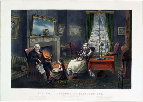
One of the conclusions I came to was that general American “scenic” prints (scenes of charming houses in the woods or country and that type of thing) were the most popular type of prints in both periods. I think that the nostalgia of the 1920s for this idyllic, sylvan life-style is still present with Americans. Our forefathers never, of course, had such a simple and pleasant life, but this ideal image is clearly as strongly embedded in our national consciousness today as it was almost a century ago.


In contrast, perhaps the biggest difference between the lists from the different periods I noticed was the popularity of American historical prints with the Original lists compared to their singular lack of popularity in the New lists.


There were actually two lists for each period, one for large folio prints and one for small folio prints, but in both cases there was more popularity for historical prints in the Original prints versus the New prints. This was especially pronounced with the small folio lists. In the Original Best 50 small folio list there were 13 historical prints, over a quarter of the list. In the New Best 50 small folio list there was only one historical print, a mere 2% of the New 50.


When one looks at which historical prints were in the Original list, the vast majority were from the distant American past, not the more recent past, and even more interesting, their subjects were of events that took place before the Currier & Ives firm was producing prints, not those they issued on contemporary events.


For instance, there was only one war print in this list from those the firm issued contemporary to the events shown. There were none from the Mexican-American War and only one of the Civil War image “Terrific Combat Between the Monitor…and the Merrimac,” even though Currier & Ives issued many prints of both wars during the conflicts. Instead, most of the prints were from the American Revolution, e.g. “Washington Cross the Delaware,” “Cornwallis Is Taken!”, or even earlier, for instance, “Landing of the Pilgrims.”


Brandenburg’s article, I think, helps explain why these Revolutionary War and early American history prints were so popular early in the twentieth century. As she wrote, “Uncomfortable with the present and anxious about the future, Americans turned their eyes to the past—or at least to a particular vision of an American past that seemed more authentic, uncomplicated, and pure.” It was the early settlers and the founding fathers who expressed in clear terms what American was about, not the complicated issues and uncertainties of the Civil War, so it was these idealized prints which fit the American public’s mood at that time.


Today, in contrast, I think that while we still have an idealized vision in our heads of what life was like in the simpler past, we no more see the founding of this country as such a clear-cut noble and pure event. Instead, the approach to our history that most collectors have today is for authenticity rather than nostalgia.


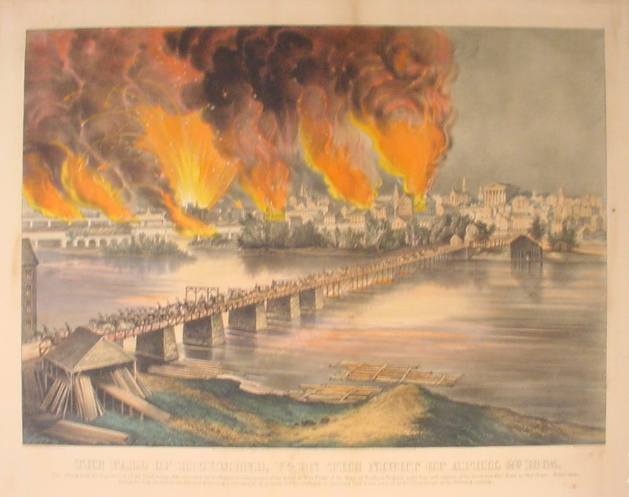
Today, collectors want, as much as possible, contemporary and accurate images of American history, not idealized images drawn by commercial artists a century after the fact. Even those prints by Currier & Ives which copy contemporary images have much less appeal as they add nothing to the original prints. It is interesting that the only historical print to make the New Best 50 small folio list was a contemporary print from the Civil War, “The Fall of Richmond, Virginia.”


There is much more to chew on by looking at tastes for Currier & Ives prints now, early in the last century, and of course at the time they were issued. Hazel Brandenburg’s "Re-Presenting the Past: Currier & Ives in 1920s America" is a really nice addition to the literature on this subject and well worth a read.


Tuesday, August 14, 2012

Shaping the Trans-Mississippi West: 1840-1849. Part 3.

In the previous two blogs of the series "Shaping the Trans-Mississippi West," we looked at how two huge areas were added to the United States between 1840 and 1849, the Oregon Territory and the Mexican Cession. While these were the most important developments in the country in this period, there was some redrawing of borders in the northern part of the original Louisiana Territory during this decade.


That development had its origins almost as far back as the Louisiana Purchase, with the creation of the Michigan Territory in 1805. This territory was originally carved out of the lands that lay north of the Ohio River and east of the Mississippi River, what was called then the Northwest Territory. In 1834, that part of the Louisiana Purchase between the Mississippi and Missouri Rivers, to the north of the state of Missouri became attached to the Michigan Territory. This area included all of today’s Iowa, Minnesota, and the eastern parts of the Dakotas.


Two years later, in 1836, the western part of the Michigan Territory was organized as the Wisconsin Territory, in anticipation of the remainder of the territory becoming the state of Michigan in 1837.


In 1838, this territory was broken up so that only those lands to the east of the Mississippi River remained as the Wisconsin Territory, the western section being created as the Iowa Territory.


Settlers had begun to pour into the Iowa Territory in the early 1830s and by the beginning of the next decade there was sufficient population in the southern part of the territory to warrant creating a state there. Iowa was admitted as a state in 1846, in part to balance the admission the year before of the slave state of Florida with a new free-soil state. The remainder of what had been the Iowa Territory, those lands north of Iowa lying between the Mississippi and Missouri Rivers, together with the northwest part of the Wisconsin Territory which was left over when the state of Wisconsin was created in 1848, become the Minnesota Territory in 1849.


The creation of the Minnesota Territory was the only official political change in the trans-Mississippi West east of the continental divide in this decade. However, this period did see the beginning of a movement to create a new territory which would see fruition in the 1850s.


With the increased emigration of Americans to Oregon Country and California beginning in the 1830s, there was concern in Washington of the need for the development of the lands through which the emigrants would have to pass on their way from the Mississippi River to the Rockies. The necessity of a military presence for protection, a formal government structure for laws, and settlers to help feed and house the emigrants made it evident that a new territory was needed across the midsection of the vast Indian Territory which had been created in 1834.


The name for this proposed territory was to be "Nebraska," a name first used by Fremont to refer to the Platte River, which was for much of its length a main route for the emigrants. "Nebrathka," was an Otoe word for 'flat water' and was used by them as the name for the Platte. A bill to create the Nebraska Territory was introduced in 1844, with another put forth in 1848; both failed at this time because of the sectional differences between North and South. It would take many years before these differences were able to be overcome.


Go to next blog in this series, on political developments in the 1850s.