Wednesday, December 2, 2015

Dr. Syntax

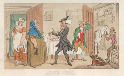
One of my favorite series of British prints are the delightful images drawn by Thomas Rowlandson of the (mis-) adventures of Dr. Syntax. These colorful prints are a delight to the eye and also have a wonderful humor, showing this elderly schoolmaster in various situations that reflect the daily life of early nineteenth century England. So who was this Dr. Syntax and why were these prints made?


Dr. Syntax was a totally fictional character. From 1812 through 1821, a series of volumes were published about the “tours” of Dr. Syntax. The prints were issued along with poems by James Combe, with the always humorous misadventures of the parson Dr. Syntax portrayed both in verse and picture. The story of Dr. Syntax first appeared in Ackermann’s Poetical Magazine from 1809 to 1811, and its popularity resulted in the publication in 1812 of Tour of Dr. Syntax in search of the Pictureque.


These adventures and illustrations were issued in response to the thousands of early nineteenth-century tourists that swarmed the English countryside in search of the picturesque. Obsessed with finding “natural” beauty, these vacationers often found themselves in very artificial situations. This invited the the tease of Rowlandson’s and Combe’s wit, as they satirized the Reverend William Gilpin’s flowery accounts of his picturesque tours, works very familiar to Britain’s middle and upper classes. In place of Gilpin, the satirists insert stumbling clergyman Dr. Syntax into highly detailed landscapes and interiors. Like all good caricature, they comically twist current events and trends to produce visual jokes that transcend period and place.


This work got its start through a series of drawings done by Rowlandson showing an elderly clergyman and schoolmaster who traveled during his holidays looking for the picturesque. Rowlandson had offered these to printseller and publisher to Rudolph Ackermann who was just about to begin his Poetical Magazine. Realized that the images would do better with text, Ackermann approached William Combe to provide “poems” to accompany the images.


Such was the success of the first volume that two more “tours” appeared, with Dr. Syntax in search of consolation and then of a wife. The process of the production of the tours is interesting, for Combe’s doggerel was always based on Rowlandson’s images. Once a month a new drawing would be furnished to Combe, who would write up an account to match the image. This went on for years and interestingly, Combe wrote that “the artist and the writer [had] no personal communication with, or knowledge of each other”!


The story and pictures of Dr. Syntax were a huge success, leading to the popularity of “Syntax hats,” “Syntax wigs,” and “Syntax coats.” The Staffordshire china firm of Clews got into the act with a series of plates and other china showing the good doctor.


There were also some Staffordshire figures done showing scenes from the series.


Not only are these prints a delight, but they are still generally available and affordable to collectors today.


Wednesday, November 18, 2015

Under the Guillotine: Exhibit of caricatures by James Gillray.

A terrific exhibit featuring caricatures by James Gillray will be appearing at the Center for Visual Art at Metro State University of Denver. Curated by Cecily Cullen, the exhibit is drawn from the amazing collection of British caricature prints owned by Professor Arthur N. Gilbert.


James Gillray one of the greatest of political caricaturists and this exhibit is part of the celebration of the 200th anniversary of his death. Gillray (1756-1815) made a name for himself through his witty compositions, capable draftsmanship, and exquisite detail. Through his copious political satires, he set a new standard for the genre, becoming a measure by which his successors were judged. He satirized both British society and royalty and foreign figures. Napoleon particularly attracted his etching needle, and Napoleon one states the Gillray did more to cause his defeat than all the armies of Europe.


Gillray’s caricatures were published as etching, each of which was hand colored, mostly by women whose names are unknown today. They are all delightful simply in their appearance, but well reward careful study. They were sometimes relatively benign, but could also be very pointed and even savage. This exhibit is dedicated to the editor and staff of Charlie Hebdo and it is interesting to contrast today’s society with that of England at the time, where this sort of very intense caricature was so well tolerated.


The exhibit runs from December 18th until March 19th, and other events are planned. More information can be found on the Metro State website.

Thursday, October 8, 2015

Mourning Prints for George Washington

On December 14, 1799, George Washington passed away at Mount Vernon and the nation went into deep mourning. Washington was a figure revered by most Americans so his death took on an almost religious aspect and citizens from all walks of life wanted to memorialize the “Father of his country.” Thus right from the start of the nineteenth century, there was a large outpouring of objects of art honoring his life and commemorating his death. These included drawings, paintings, needlework and embroidery, and—-of course-—prints.


Interestingly, one of the first memorial prints of Washington was issued in London on April 10, 1800. Entitled “George Washington Late President of the United States,” it was engraved by P. Roberts and dedicated “to the friends of the Above Gentleman.” A bust portrait, based on a painting by American artist William Birch, is set into a scene with weapons of war and flags, giving Washington a setting of military glory.

Perhaps the earliest American morning print, “Sacred to the Memory of the truly Illustrious George Washington,” was designed by John Coles, Jr., engraved by Enoch G. Gridley, and published in Boston in July 1800. A large marble monument glorifies this “Great and Good Man.” A portrait of Washington, based on Edward Savages 1792 engraving, is held by Minerva, representing Washington’s military past. Fame hovers above the portrait blowing a trumpet from which hangs a banner listing Washington’s Revolutionary War triumphs. A weeping Columbia morns the loss of her son, as does a soldier standing in front of the monument.

Shortly after that print appear, in December 1800, this a stipple engraving by David Edwin, based on a drawing by Rembrandt Peale, was issued. Entitled “Apotheosis of Washington,” the President is shown rising to heaven from Mount Vernon (shown in the bottom right of the image) with a cherubim holding above his head a wreath of Immortality. Two figures look on, welcoming Washington, representing two slain Revolutionary War generals, Richard Montgomery and Joseph Warren.

The notion of the apotheosis of Washington led to the publication, in 1802, of another print on this theme, based on another important American artist of the period, John James Barralet. The initial advertisement for the print described it thusly, “The subject—General Washington raised from the tomb, by the spiritual and temporal Genius [that is ‘Father Time’]—assisted by Immortality. At his feet America weeping over his Armour, holding the staff surmounted by the cap of Liberty, emblematical of his mild administration, on the opposite side, an Indian crouched in surly sorrow. In the third ground the mental virtues, Faith, Hope, and Charity.” Other symbols in the picture include several representations of the Washington’s country; the American Eagle and Crest, as well as rattlesnakes, which referred to America’s revolutionary spirit. This print was so popular that it went through at least four states and was copied into other forms, including transfer china.

A number of prints focused on the fact that the people of the United States continued to mourn for Washington. This print by Boston printmaker Thomas Clarke, issued in 1801, shows a man and woman weeping into handkerchiefs while being consoled by a figure of Hope, who points to heaven and has the symbol of an anchor (“Hope...as an anchor of the soul.”). A monument to Washington, with his face engraved below a cherubim is set below a weeping willow.

The publication of Washington mourning images slowed down for a number of years, but the renewed patriotism motivated by the War of 1812 inspired a new group of such prints. One of these was a calligraphic image, a popular type of print at the time. This was drawn and published by Benjamin O. Tyler, “Professor of Penmanship,” in 1817, engraved by Peter Maverick. The print is entitled “Eulogium Sacred to the Memory of the Illustrious George Washington, Columbia’s Great and Successful Son: Honored Be His Name,” and in it Tyler uses clever symbols and other images.

This sort of print remained popular, as demonstrated by a second calligraphic memorial print, “Sacred to the Memory of the Illustrious Champion of Liberty, General George Washington; First President of the United States of America, issued about two decades later by John I. Donlevy. The face of the portrait is done with straight engraving, but the rest of the bust is made up of effusive swirls, and the writing gives the title and dates in Washington’s life.

Another print from the 1830s was a third apotheosis print, a lithograph issued in London based on a painting by Samuel Moore. The image is explicated by text at the bottom, but the image is readily understood even today. At the top, Washington is being born to heaven by the seven virtues, "the inmates of his Soul in his terrestial Pilgrimmage." Beneath, just below the American crest with its eagle, stands Columbia, "who looks up to him [Washington] as the rock of her consolation." In the foreground are shown the sixteen "Orphan States, dissolving in sorrow at his Tomb, and lamenting the departure of their adored Friend, Benefactor, and Protector." This refers to the sixteen state which were part of the U.S. at the time of Washington’s death.



Monday, September 21, 2015

The origins of the Nebraska Territory

With the Louisiana Purchase of 1803, the United States essentially doubled its territory with the addition of the lands drained by the Mississippi to the west of that river. This area was mostly unknown, so the federal government tried to learn more about this new American territory by sending out a number of exploring parties, including those of Lewis & Clark in 1804-1806 and Stephen H. Long in 1820, and these expeditions did provide some understanding of the geography of the Louisiana Purchase.


One of the main reasons for acquiring the area was so the United States would eventually be able to open up an outlet for the nation on the Pacific Ocean, but also to provide new lands for emigrants from the east. Americans soon moved into the areas just to the west of the Mississippi, for instance into what would become Missouri and Iowa. By the 1820s, there was considerable settlement in the Louisiana Purchase lands near to the Mississippi River from New Orleans up to St. Louis, but beyond that there little American presence.


There was little incentive at the time for Americans to move into the western parts of the original Louisiana Territory. Reports from the western expeditions had not been glowing in their descriptions of region-—Stephen Long described the High Plains as a “desert”-—and it was already extensively occupied by Native American tribes. And on to top of this, it was far removed from the center of economic and political life in the U.S., bordered beyond by seemingly impenetrable mountains and then Spanish territory.


This made it the ideal place to help solve one of the vexing issues Americans were facing at the time, viz. what to do with the Native Americans in the East. Unlike the western tribes, those in the East occupied lands which were coveted by the Euro-Americans and in the 1820s, the federal government began a policy of moving the Eastern Indians to lands west of the Mississippi, culminating in the Indian Removal Act of 1830. This seemed a perfect solution-—to the Euro-Americans-—for they would gain lands they desired and gave up lands that were deemed essentially useless for civilized folk. An additional benefit was that this would set up a buffer between the United States and the Spanish, protecting the countries back door.


So, in 1834, an Indian Intercourse Act set aside for Native Americans "…all that part of the United States west of the Mississippi and not within the states of Missouri and Louisiana, or the territory of Arkansas…" This Indian Territory was steadily reduced over the years, but by 1845 in what had been the Louisiana Purchase, other than a single row of states and territories strung along the Mississippi River, the rest was unorganized Indian lands.


The out-of-the-way, practically useless character of this region, which made it such a perfect place to stick the Native Americans, was soon to radically change. With the increased emigration of Americans to the Oregon Country and California beginning in the 1830s, there was concern in Washington of the need for the development of the lands through which the emigrants would have to pass on their way from the Mississippi River to the Rockies. The need for a military presence for protection, a formal government structure for laws, laws for economic development, and new settlements to help feed and house the emigrants, all made it evident that there had to be some sort of governmental presence crossing the Indian Territory.


Then with the 1848 Treaty of Guadalupe Hidalgo, which ended the Mexican War, the urgency of this was made even greater. By the Mexican Cession, the United States gained another huge swath of territory, now extending the country from the Atlantic to the Pacific Ocean. The Indian Territory was now no longer at the inaccessible, back-end of the country, but was smack-dab in the middle, between “the States” and newly gained California. The Indian Territory now separated the population, money and power of the East Coast from the golden lands on the Pacific. What had been a buffer was now a barrier. Travel by sea, either around the tip of South America or by way of a land crossing at Panama, was possible, but it was quite clear that a land route across the Indian Territory-—preferably by railroad-—was something that was an economic, social and political necessity.


The need for some sort of U.S. government control over a land bridge between the territories and states along the Mississippi River and California and Oregon was clear. Between 1844 and 1854 there were 8 proposals for a new territory spanning the Indian Country. The name for this proposed territory was to be "Nebraska," a name first used by Frémont to refer to the Platte River, which was for much of its length the main route for the emigrants heading west. "Nebrathka," was an Otoe word for ‘flat water' and was used by them as the name for the Platte.


The first official proposal was by Secretary of War William Wilkins in his annual report of Nov. 30, 1844. This was taken up by Stephen Douglas with House bills in December 1844. The idea was to create a territory along the Platte River Valley with a string of military posts from the Missouri River to the Rocky Mountains. These bills failed. Another bill was put forth in 1848, and others in 1850 & 1852 & 1853, but all failed.


A number of maps in this period show these tentative Nebraska Territories. The reason none of these acts were passed was because of sectional tensions over slavery. Southerners continued to stonewall the creation of a Nebraska Territory in this region, for any such territory would, by the Missouri Compromise, have to be a free territory.


It wasn’t until Stephen Douglas’s Kansas-Nebraska Act of 1854 that a Nebraska Territory was finally created spanning the Great Plains and allowing for the building of a trans-continental railroad. The final territory was quite different than those previously proposed, for not only was it joined by another new territory to the south, Kansas, but it encompassed about half of what had been Indian Territory. By this act, the territory set aside for specifically for the Indians shrunk to just what is today’s Oklahoma (actually, the panhandle of today’s Oklahoma was not then included in the Indian Territory).


Tuesday, August 25, 2015

Mapping your Marriage in the 1850s by Vince Szilagyi

We see maps of all sorts in our line of work, but recently the shop acquired one that had even us shaking our heads in amusement. The map in question is a marvelous and charming 1850 lithograph by Philadelphia printmaker Augustus Kollner which examines and charts one of the most important and difficult areas of the human experience, marriage!


At the top of this map, an appropriately solemn wedding is being conducted in front of a crowd of earnestly praying guests. Beneath this scene lies “The Great Ocean of Love.” This ocean, according to the text on the map, “represents a period of life that all persons are supposed at some time or another to pass. By an examination of the chart voyagers will be enabled to avoid the dangers that beset them, and arrive safely at the haven of felicity."


The aforementioned dangers are graphically illustrated in the map by the numerous islands, bays, straits, gulfs, harbors, rivers and other geographic features which dot the Ocean of Love with names like “The Rocks of Jealousy”, “Mountains of Deceit” and “Divorce Isle”. The left and right sides of the map are filled with text detailing the various locations in the Ocean of Love, and how they are to be traversed safely in order to reach a happy and loving marriage. The dangers presented range from the serious, [“River of Abuse”, “Mountains of Hatred”], to flippant [“Silly Isles”] to memorable [“Hymen’s Light-House”]. Guiding the would-be lovers is a compass rose in the bottom left corner, on which the cardinal directions are Hope, Love, Despair and Hatred.


My personal favorite of the obstacles and descriptions is Port Desire. “Port Desire, From what cause we are unable to explain, is not visible on any of the Charts. Yet it affirmed to by many, that from time immemorial, it has been a place of great resort, by all classes. The tides about the coast are very rapid, so much so, as to rise and fall almost beyond the power of imagination. In running for the harbor, it is necessary to bear up betwixt the rocks of Philosophy and Prudence. After passing them, the traveler may be considered clear of danger, always taking care never to bring too at shallow water.” While Bachelor Fort, is a strong contender, Port Desire neatly encapsulates the unique combination of 1850’s American culture, artwork and humor that make this map so charming.


This print is exceedingly rare, with the only other extant example we could find being a copy at the Library of Congress. However, as seen above, this copy lacks the descriptive text along the left and right of the image. The Library of Congress states that this space was for recording marriages but we disagree. We feel that the blank columns indicate that this version of the map was sent to the Library of Congress before the print was finished as a copyright copy, designed to guarantee Kollner ownership of the image itself. With the copyright secure, Kollner finished the map and began to sell copies with descriptive text in the columns, like the one the shop now holds.


Although this particular map is rare, there are some other matrimonial maps in private collections and in the hands of particular dealers. Matrimonial maps originated in late 18th century in Europe, and became fairly popular in the 19th century in both Europe and the United States. Maps like this were used both as décor and as a tool to help preserve the virtue of young men and women and help guide them into happy, stable marriages. Using these maps people could avoid obstacles like the “Sands of Inconstancy” and the “Floating Isles of Flattery” and eventually reach the promised land of “Lake Affection” and “Baby Fort”. Some struggles really are timeless.


Matrimonial maps faded in popularity but some examples of 20th century maps do exist. A British collector and antiques dealer named Rod Barron has a wonderful collection of matrimonial maps on his website Thanks to the Library of Congress and to Ella Morton at www.altaobscura.com for putting us on to Mr. Barron’s collection.

Wednesday, August 5, 2015

American State Exclaves: The Dakota Thump

One of my favorite exclaves is the Dakota Thumb, which existed for five years in the Bitterroot Mountains, where a part of the Dakota Territory lay separated from the main part of Dakota by about 365 miles!


In 1838, the northeastern part of the original Louisiana Territory, those lands lying between the Mississippi and Missouri Rivers, north of the state of Missouri, became a very large Iowa Territory.


Eight years later, the southeastern part of the territory was admitted as the state of Iowa, with the remainder of the region—those lands between the Mississippi and Missouri River north of Iowa, becoming the Minnesota Territory in 1849.


In 1850, the vast lands north of Texas between the Missouri River and the Continental Divide were unorganized, with no formal government. The 1854 Kansas-Nebraska Act created two large territories in this area, with a vast Nebraska Territory consisting of all the lands north of the 40th parallel that lay west of the Minnesota Territory and east of the continent divide.


Four years later, the eastern part of the Minnesota Territory was made into a state, with the western part being left legally unorganized, though a provisional government for a territory to be called Dakota was set up.


It wasn’t until 1861 that the Dakota Territory was officially created, but when it was created it was much larger, encompassing not only what had been the western part of the old Minnesota Territory, but also that part of Nebraska Territory north of the 43rd parallel.


At about this time, gold was discovered in the eastern part of Washington Territory (which basically surrounded the state of Oregon in the northwest) and as new emigrants moved into the area, it was decided in 1863 to create a new territory—-called Idaho-—which included not only the eastern part of Washington Territory, but extended well to the east, as far as the 104th degree longitude. This included what had been the western part of the very large Dakota Territory, leaving Dakota encompassing what is today North and South Dakota.


Within a year, miners in the eastern part of the vast Idaho Territory requested that a new territory be created for them. They were located on the eastern side of the Bitterroot Mountain Range and felt cut off from, and ignored, by the Idaho government located on the far side of the Bitterroots. Thus in 1864, the Montana Territory was created. Its eastern border was the old Idaho Territory with Dakota down to the 45th parallel. The southern border followed this line of latitude to 111 degrees west, then turning south for half a degree (44°30’), where it turned west again until it ran into the Continental Divide in the Bitterroots. From thence it ran along the crest of those mountains until it intersected the 116th degree line, which it then followed to the Canadian border.


Idaho’s border was also redrawn south of the 44°30’ line. It followed the Bitterroot range as far as the 100th degree, at which point it dropped straight south until it intersected with the Utah border. This left an almost-rectangular shaped section of land south of Montana—-which had been part of Idaho Territory-—which now was attached to Dakota Territory, giving it a strange butterfly-like shape.


The re-enlarged Dakota was not only very large, but its strange shape was impractical, so in 1868, the southwestern block was separated to become Wyoming. This territory was created as a rectangle, with the eastern border simply continuing the Montana border down to Colorado, thence running along the 41st parallel to the 111th meridian, which the border then followed up to the Montana border at the 45th parallel.


This all sounds very reasonable, but a small exclave was created because of how the borders of Wyoming, Idaho and Montana were defined.
  • Wyoming’s western border was the 111th meridian
  • Idaho’s border followed the Continental Divide until it intersected with the 111th degree line
  • Montana’s border followed the 111th meridian to 44°30’, whence it turned west until that line intersected the continental divide.
The map above shows how Wyoming would have looked if Congress had not determined to make it a rectangle. That little pointed bit at the left is the area which would have been included in Wyoming, but was not.


That little wedge of land was actually left out of all the territories because the Continental Divide runs into the 111th degree line south of 44°30’. As it had been part of the Dakota Territory previously, and the new borders didn’t change its status, this little “thumb” of land remained part of Dakota, detached and well west of the rest of that territory. Very few maps show the thmub; the detail above comes from the 1868 GLO map of the United States. The thumb remained as part of Dakota until 1873, at which time it was given to Montana.


Tuesday, July 14, 2015

American State Exclaves: The Kentucky Bend

An exclave is a section of land which is not conterminous with a larger political entity to which it belongs. That is, an exclave is physically separated from the main part of its political unit by one or more other political entities, so that is would be impossible to get by land from the exclave to the main part of the political entity without crossing territory belonging to a foreign entity. An example of such an exclave in the United States is Alaska. (Note that, strictly speaking, an exclave has to be surrounded by alien territory, but in this discussion we will include pene-exclaves, or practical exclaves, such as Alaska, which are partially bordered by their own territorial waters.)


There are quite a number of exclaves in the world, most of them of very local character (for instance as part of a county or city). Over the years, however, there have been some interesting exclaves as part of American states. One of the earliest was what is today the state of Maine, which from the seventeenth century until 1820, when it was admitted as as state, was part of Massachusetts. Another was the Western Reserve, in present-day Ohio, which was an exclave of Connecticut until the year 1800.


Those exclaves were the result of political claims, but there are three interesting U.S. state exclaves which were created becaue of maps, which of course is of particular interest to me. In today’s blog we’ll look at the 17 square miles called the “Kentucky Bend” (also the “New Madrid Bend” or “Bessie Bend”).


In 1663, King Charles II created the Carolina Colony, establishing it to the south of the Virginia Colony with their mutual border being set at 36 degrees, 30 minutes. (This border is one of the most significant borders in the United States, playing a huge role in the history of slavery and the American West, as explained in my blog on “Shaping the Trans-Mississippi West”). In 1792, Kentucky was created as a state out of the western part of Virginia, retaining the same southern border. Its western border was set as the Mississippi River where 36°30’ intersected it.


Initially, this seemed to be unproblematic, as the 1795 map of Kentucky by Mathew Carey shows. However, surveyors did not actually lay the border on the ground that far west until well into the 19th century (and, indeed, the surveying of the border between Kentucky and Tennessee further east was also problematic, creating anything but a straight line along the 36°30’ border).


As better surveying of the region of western Kentucky, southern Missouri and the Mississippi River around New Madrid was gained, the realization came that the Mississippi River came awfully close to the 36°30’ line in the area, as Anthony Finley shows in his 1824 map.


By the beginning of the next decade, it was discovered that the Mississippi River, on one of its meander loops, actually crossed that line of latitude three times, creating a small peninsula which stuck up north of the border line, which made it part of Kentucky, but which was not connected to the main part of the state to the east. This is nicely shown on Henry S. Tanner’s map of 1833. According to Kentucky, that peninsula, though unattached to the rest of the state, belonged to her, as it has been since accepted. Tennessee, however, initially claimed the peninsula as well, only giving up its claim in 1848. The Kentucky Bend is an exclave, as you cannot get from it to the rest of Kentucky without crossing either into Missouri or Tennessee.


Some have claimed that the river originally did not drop south of the 36°30’ line until it flowed past New Madrid, but that its course was changed by the large earthquakes centered on that town in 1811 and 1812. That would have meant that this exclave was originally attached to the rest of the state. However, it does not appear that this shift in the river ever happened (though the Mississippi did, in effect, flow backwards in the region at one time because of those quakes). This unusual exclave, shown on the map above by Jim Efaw, was simply the result of borders being defined on maps before those maps were truly accurate.