Saturday, July 16, 2011

Indian prints by W.M. Cary

Next week I am heading off for another Antiques Roadshow taping, this time in Tulsa, Oklahoma. For those interested in western art, this means one thing: the Gilcrease Museum, one of the greatest museums of the art of the West.

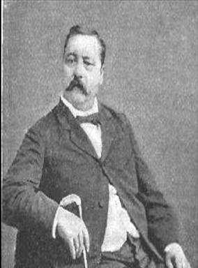
My pending visit to Tulsa, together with our recent acquisition of a good collection of prints of the American West from Harper's Weekly, got me thinking about William de la Montagne Cary (1840-1922), better known to print collectors as W.M. Cary. That is because when Cary died, a large collection of his paintings and drawings were acquired by Thomas Gilcrease and they now reside at the Gilcrease Museum.

Cary was one of the significant contributors to the depiction of the American West in illustrated newspapers. His Western prints appeared beginning in the late 1860s and then continuing in subsequent decades, mostly in Harper's Weekly, but also in Frank Leslie's Illustrated Newspaper and other illustrated periodicals. Like most of his fellow Western illustrators, Cary based his drawings on his own experience in the American West.

Cary began his art career at age fourteen as an apprentice to a commercial engraver. By age 20, he had worked in watercolor and oil, done some sculpture and had contributed a number of drawings to illustrated periodicals, such as the Aldine. Though encouraged by his family to pursue his artistic career through formal study abroad, Cary decided he wanted to seek adventure in the American West.

In early 1861, with two friends, Cary set off on a “sporting expedition” to the West, traveling from St. Louis, aboard American Fur Company steamers, up the Missouri to Montana, surviving a fire and exploding boiler along the way. They spent six weeks at Fort Union, hunting and befriending the Indians camped around the fort. Then the young men joined a wagon train and set off to Fort Benton. Along the way they were captured and then released by a band of Crow Indians, and upon arriving at Fort Benton they stayed for another two weeks hunting and exploring the area. From thence the threesome set off by foot and horseback across the Rockies to Washington State, subsequently returning back to New York City about a year after they had set out.

In 1867, Cary went West again, where he painted portraits of George Custer and William “Buffalo Bill” Cody, the latter becoming a lifelong friend. In 1874, Cary made a last trip to the West, joining in with the U.S. Northern Boundary Survey Commission on the last part of their expedition.

In New York City, Cary had set up a studio and became a well-established artist, known particularly for his western themed art. Cary produced paintings and also a number of images which were made into lithographs, etchings and book plates. His most prolific work, however, were the images he provided for the illustrated publications.

His periodical illustrations are of considerable interest. Many were based on first-hand observations and others were “imaginary scenes suggested by events at the time of their depiction,” (Robert Taft, Artists and Illustrators of the Old West, p. 53) though always informed by his considerable experience in the West. With our recent acquisition of a group of Harper's Weekly wood-engravings of the West, I was particularly struck by W.M. Cary's images of Native Americans.

Relationships between the Plains Indians and the EuroAmerican emigrants from east of the Mississippi, who passed through and then into the region in increasing numbers, had been problematic from 1850s on, with an on-going series of conflicts scattered in among a regular succession of "wars" and treaties. With the discovery of gold and the building of railroads across the Plains, "Indian Wars" were a regular occurrence and readers in the East had an insatiable interest in news of the dramatic events on the frontier.

Accounts appeared in books and periodicals, but the most common form of visual information about the Indian affairs of the West were the wood engravings from the illustrated newspapers. Cary was one of the most prolific contributors to this body of images in the 1860s and 70s, and he probably was the artist whose drawings were the most dramatic. Thus, it is not unlikely that Cary's prints contributed a large element to the visual image that most EuroAmerican's had of the Native Americans.

So what were they like; what sort of image did Cary give on the American Indian? The sample is somewhat small and so my thoughts that follow are very speculative, but I think it is interesting see what we can discern by looking at Cary's prints.

The prints from the 1860s were drawn when Cary was still in his 20s and not long after he had lived through a number of his own adventures in the West. These prints show the Indians as blood-thirsty and with exotic customs. They are shown attacking a fort and a boat-load of trappers and sneaking up to ambush peaceful settlers. The centerpiece of his "Life of An Indian" shows a brave proudly holding up his "First Scalp," while other images show him hunting and undergoing the "Trial of Endurance." It should be noted that in this print there is a nice vignette of an Indian mother and infant and also of a brave playing a flute for his son. Still, the Cary images of this period emphasize the wild and war-like.

The prints from the 1870s do, I think, exhibit a different emphasis (that is excepting Cary's wonderful image from the Aldine in 1873, showing the results of an Indian attack on a Pike's Peak gold-rusher, illustrated at the bottom). In his prints from the 1870s, Cary shows more images of Indian life, such as a canoe race, breaking a pony, and dealing with death.

In 1874, Cary did produce two images entitled "Sketches of Indian Warfare," including a scene of the Scalp Dance, but the other engraving shows the Indian less threatening than threatened. A chief stands on his horse, raising his hand to try to stop a wagon train passing through his lands. The Indian, armed only with a bow, spear and tomahawk, is facing men clearly armed to the teeth with guns and a train of innumerable wagons. One gets the sense that Cary no longer saw the Indians as wild savages (though it is not clear he ever did, for the earlier emphasis may have been more for popular consumption than his true feelings), but as members a doomed culture worthy of trying to understand.

Wednesday, July 6, 2011

Shaping the Trans-Mississippi West: 1810-1819

In the previous blog in this series, we saw how in the first decade of the nineteenth century, the United States approximately doubled its size with the acquisition of the Louisiana Purchase, from which the Territory of Orleans—-consisting of those relatively settled lands in the southernmost part of the purchase-—was broken off as a separate entity.

While the basic outline of the Louisiana Purchase was fairly clear, essentially encompassing the lands west of the Mississippi River, drained by that river and its tributaries, the exact borders between the new American lands and those of New Spain in the southernmost part were open to debate. The Americans claimed that the Sabine River should be the border, whereas the Spanish claimed a border further to the east at the Calcasieu River.

Negotiations between the countries broke down in 1805, with Spain severing diplomatic relations with the United States. Over the next year there was conflict, in words and deeds, between the two countries over the lands between these two rivers. Finally in 1806, an agreement was signed to establish this as a neutral ground, which neither side would settle nor try to govern. Inevitably, into this lawless land, lawless individuals gathered and it became a hotbed for bandits who preyed on travelers. The border was eventually established as the Sabine River by the Adams-Onis Treaty of 1819.

As I mentioned in the previous blog in this series, the large territories which were added to the United States west of the Mississippi River in the nineteenth century were divided into smaller units as they became settled; usually these smaller units were created first as territories, then later admitted as states once they reached a certain level of development.

In 1812, the Territory of Orleans became the State of Louisiana, but this had as much to do with the issue of slavery as with the region's development. Since the founding of the nation, there had been a fairly even balance between slave and non-slave states, but this was disturbed with the admission of Ohio in 1803, which would soon be followed by other non-slave states created out of the old Northwest Territory. Southerners were keen to add a new slave state to balance this trend, so Louisiana was admitted less than a decade after Orleans had been created as a separate territory.

That same year, in order that it not be confused with the new state of Louisiana, what had been the Louisiana Territory was renamed as the Missouri Territory. This was the remainder of the original Louisiana Purchase outside the new state. At that time, these borders were still not firmly established, but by the end of the second decade of the century, the borders in the north and south were defined by agreement with Britain and Spain respectively.

To the north, the border with the British in what is today Canada was established by the Anglo-American Convention of 1818, to follow the 49th parallel from Lake of the Woods to the continental divide. This in effect gave the United States the southernmost part of the Red River Valley and the British the northernmost part of the Missouri River Valley. The Adams-Onis Treaty of 1819, which had fixed the border of the new state of Louisiana, also clarified the rest of the border between Spanish and American claims for the new Missouri Territory. The United States gave up its claim over Texas and also gave to the Spanish lands between the Red and Arkansas Rivers, essentially in exchange for Florida.

In the same year as the Adams-Onis Treaty, the Territory of Arkansas was established from the lands south of the 36.30 degree parallel, running from the Mississippi River to the new border with the Spanish lands. The year before, in 1818, Missouri had applied for statehood. Centered on St. Louis, the pattern of settlement in Missouri had left something of a gap between the proposed state and Louisiana, so it seemed prudent to organize those lands into this new territory, especially given the large immigration there beginning in 1810, of both Anglo-Americans and Native Americans.

The line between the proposed state of Missouri and Arkansas was set at the 36.30 degree line, the same parallel that separated Tennessee and Kentucky. The one exception was the Missouri “Boot Heel,” which consisted of the lands east of the St. Francis River between the 36.30 and 36 degree lines. The reason for this land being assigned to Missouri and not Arkansas was essentially that the economy and settlers of the boot heal were intimately connected with the rest of Missouri, but some interesting legends about its creation have been put forth.

One story has it that a farmer who lived there asked the government to not make his land part of Arkansas, because he heard it was so sickly in Arkansas, “Full of bears and panthers and copperhead snakes, so it ain’t safe for civilized people to stay there overnight even.” Another story tells of a love-struck surveyor who ran the line further south in order to spare the feelings of a window who lived there and believed she lived in Missouri.

While the Arkansas Territory was created in 1819, the state of Missouri didn’t appear until the following year---a story to be told in the next blog in this series. So at the beginning of 1820, the United States west of the Mississippi had its borders fairly well established and it consisted of the state of Louisiana, the territory of Arkansas, and a large Missouri Territory encompassing all else.

Thursday, June 23, 2011

Multi-view prints

In previous blogs I have discussed my interest in what I call “novelty prints”, and mentioned the amazing collection of Richard Balzer. Many prints fall into this novelty category because there are multiple ways of looking at them. Today I will discuss prints which are structured in a three-dimensional manner so that they look different depending on the angle at which you view them.

We recently acquired a very interesting example of this sort of print, which you might call a “two-way” or “accordion” print (I have never come across one of these before, so do not know if there is a proper name for this sort of print). This print was issued in Paris sometime in the nineteenth century and it is a hand colored lithograph, but of definitely unusual form.

This print has the shape of an accordion, so that if you angle it to the left, you see an image of a flower vase, and if you angle it to the right, you see portraits of the Virgin Mary and the infant Jesus. It is a little hard to tell how it was put together and I have not wanted to take it out of the frame, as it appears quite fragile, but as best I can tell this print was created by taking three prints (the vase, and then the two portraits), cutting them into strips, then pasting them on a backing sheet folded into the accordion shape.

A similar type of print appeared in the nineteenth century in America, but these add a third view, so that you see one image if the print is angled left, one image if angled right, and one image if viewed straight on. Richard Balzer calls these prints “triceniums.” These are made using three prints, two of which are cut into strips and glued back to back. These double-sided strips are then stretched on their sides, and spaced a couple inches apart above the third print. If you look at the print straight on, the strips do not block your view of the print at the back, but when viewed at an angle you see one of the other two prints.

All the triceniums that I have seen use Currier & Ives portraits related to the Civil War. They have had either George Washington or Abraham Lincoln as the print when seen straight on, and various generals (such as Grant, McClellan, Scott and Sherman) used as the two angled prints. Years ago one of these, with Lincoln used as the print at the back, hung in the Ford Theater in Washington, but I am not sure it is still there.

I have also seen a “southern” version with Jefferson Davis, Robert E. Lee and Stonewall Jackson (which I did an on-air appraisal of in an early Antiques Roadshow show), and I have been told by a fellow print dealer that he has seen a Currier & Ives tricenium with flower images.

All the ones I know of, at least those produced in America, use Currier & Ives prints. So were these published in this form by Currier & Ives? I have looked for years for any sort of advertisement or mention of this sort of print as being published by Currier & Ives themselves, but have never found any. Currier & Ives prints were ubiquitous around the time of the Civil War, and the firm did sell their prints to print sellers, bookshops, and framers around the country, so it is certainly a reasonable possibility that these prints were put together by a reseller and not Currier & Ives themselves.

Until someone finds a reference to these prints being sold or produced in the nineteenth century, the question of who put these together will be something we cannot answer. If anyone knows of any such reference or comes across one, I’d love to hear about it! I would also be keen to hear of any other examples of these multi-view prints, either using Currier & Ives prints or those by other publishers. These are a lot of fun and very little research has been done on them, something it would be nice to rectify.

Wednesday, June 15, 2011

Antiques Roadshow: Eugene

I have been remiss about getting new blog postings up, mostly because I have been doing a lot of travel of late. One of my trips was to the Antiques Roadshow taping done in Eugene, Oregon earlier this month. This was the first stop for the 2012 season (the new season begins in January and it shows the episodes filmed the summer before). It was great to see all my fellow appraisers and the crowd in Eugene was terrific. The Roadshow is still very popular (viewer numbers are continuing to go up) and the crowd in Eugene was as good as almost any city I’ve been to in the 15 years of doing the show. Everyone was very nice and I saw some great stuff.

One of the surprises was that there were not as many out-right reproductions brought to the prints and posters table as usual; there were some, but I would guess at least half of what we see in most cities are reproductions and there were considerably less in Eugene. There were also less of the tourist prints we usually see so many of (as I wrote about in a previous blog). I had hoped to see some good Oregon views, but nothing of any note in that line came in.

What came in with somewhat surprising regularity were really good maps. I am not sure why that is other than that I think the map appraisals that are shown on the Roadshow are of considerable interest to people, spiking interest in maps in general (at least I hope so!). It also might be that maps remain a bit of a mystery to many people. Most prints are fairly obvious in terms of what they are about (a local view, a portrait of a famous person, a bird print, etc.), but unless you are someone who is pretty up on history or cartography, most people know nothing about the maps they have other than the geographic area they show.

Whatever the case, I enjoy it when maps come in; most have an interesting history and I love to explain the historic context of the maps for their owners. Maps also can be quite attractive, as was the Blaeu world map that I saw. This was a map which a young lady had inherited from her father. She thought it was nice, but really didn’t know anything about it. This was a beautiful example of a Blaeu world, with original color, and when she learned both how early it was (early 17th century) and its value (over $20,000), she was flabbergasted. Fun to be able to pass on such good news rather than the usual, “Your print is very attractive, but its value is really simply as a decorative item and it would probably be priced at less than $10 in a shop…”

I also saw a number of other very good maps (one of which was taped and I hope will appear in next year’s season). One was a nice “saddle bag” version of Simeon De Witt’s important 1804 map of New York State. De Witt had been the Surveyor General for the American army during the Revolution and he later became the Surveyor General for New York State, a post he held for half a century. In 1802, De Witt produced a large map of the state, based on earlier maps along with new surveys commissioned by De Witt. Two years later, this seminal map was issued in the reduced version, a nice example of which was brought in to the Roadshow. A rare map that is one of the best American maps of the first decade of the nineteenth century.

This coming weekend I am heading off for El Paso, Texas, for the second stop on the Roadshow tour this summer. One tends to expect to see things of local interest, but then again most of the things I saw in Eugene had little to do with Oregon. There are, of course, lots of great items related to Texas history: prints and maps. As I discussed in my blog of relative values for maps of different states, anything related to Texas history tends to be worth more than things related to the history of other states, so if I see a good view, battle scene or map of Texas history, it is likely to be worth a fair bit.

This brings up an issue I’ll briefly mention to end this blog, that is the importance of price or value for items on Antiques Roadshow. Early on, it was the big prices of some of the items which were filmed ($20,000!) that caught viewer’s attention on the show. However, large prices are not enough to sustain fifteen seasons of interest. It is a good story about an item that the producers are looking for. Yes, the price is important (most regular viewers I know are always trying to guess the value of items as they watch), but the story of the items is more so. Good thing for me, as on the whole maps and prints are in the lower price range in the world of antiques, but most of them have really interesting stories (to me especially). Here’s hoping to a bunch of fascinating and valuable items in El Paso!

Saturday, May 21, 2011

Shaping the Trans-Mississippi West: 1800-1810

The United States was born out of the British Colonies, which had been founded in North America beginning in 1607. These colonies were originally limited to the lands along the Atlantic Ocean, east of the Appalachians, but with their 1763 victory in the French & Indian War, the British gained control of almost all of North America east of the Mississippi River. When the United States was formed after the War of Independence, it consisted essentially of the territory in eastern North American between the Great Lakes and St. Lawrence River in the north and Florida in the south.

At the beginning of the nineteenth century, the American western frontier consisted of the lands across the Appalachians, but east of the Mississippi. Citizens living in the area between the Appalachians and the Mississippi considered themselves westerners; for instance, Henry Clay from Kentucky was popularly known as “Harry of the West.” By the end of the century, however, the United States stretched from the Atlantic to the Pacific, and it was the trans-Mississippi region which was then the American West.

In 1800, most of the trans-Mississippi region was either Spanish or French territory. French Louisiana consisted of those lands in the Mississippi drainage to the west of the river, so lying between the Mississippi and the continental divide. The lands to the west of the continental divide were primarily Spanish, being the northern part of the Viceroyalty of New Spain, though the country north of the 42nd degree parallel was claimed also by the British.

So, in 1800, what would become the trans-Mississippi United States was divided into just three basic political entities, French Louisiana, northern New Spain, and (somewhat disputed) the British Columbia District in the Pacific Northwest. By the end of the century, this was all part of the United States and by then it was divided into 23 political units! The changing political configurations of the trans-Mississippi region between 1800 and 1900, as shown in contemporary maps, will be the subject of a series of blogs I will call “Shaping the Trans-Mississippi West.” Today I’ll look at the first decade of the 19th century.

French Louisiana originally consisted of most of the drainage basin of the Mississippi, on both sides of the river. In 1764, with her loss at the end of the Seven Year’s War (called the French & Indian War in North America), France relinquished the eastern half to the British and the western half to the Spanish. France regained control of Louisiana west of the Mississippi from the Spanish in 1800.

In the first few years of the nineteenth century, Napoleon Bonaparte was involved in much conflict and intrigue in Europe and the French dominions abroad, and he faced imminent war with the British and total financial collapse. Looking for a quick solution for the latter, in 1803 Napoleon sold Louisiana to the United States for essentially 15 million dollars (about 220 million in today’s dollars), the equivalent of less than 3 cents per acre.

In this one transaction, the United States essentially doubled its size. The exact border between the Spanish lands in New Spain and Louisiana south of the continental divide were not clear, but that was settled by the Adams-Onis Treaty of 1819. There was also still dispute about the ownership of the lands in the Pacific Northwest. Little was known of Louisiana, so President Jefferson almost immediately sent out an exploring expedition under Meriwether Lewis and William Clark. Early maps were able to show a rough image of this newly acquired U.S. territory, but it wasn’t until the Lewis & Clark information and then later exploring expeditions that accurate details began to become available.

There are a number of common themes which we will see as we study the development of the trans-Mississippi West, one of which is that initially large territories were divided into smaller units as their population increased. Citizens would move into part of a large territory and would soon feel a desire for a more local government, which could take into account the particular needs and wants of that local population. These smaller units were usually also territories, but then over time they would usually become states (unless they were again subdivided).

Thus it was that in 1804, that part of the Louisiana Purchase south of the 33rd parallel became the Territory of Orleans. This was, of course, the area where there had been a large and sophisticated population of Spanish, French and now American citizens, who felt that they had little in common with the vast, undeveloped parts of Louisiana to the north. The remainder of the purchase, north of Orleans, became the unorganized District of Louisiana, which then became the Louisiana Territory in 1805.

Thus the political situation of the trans-Mississippi West in 1810 was very like that in 1800, though now divided into four parts instead of three: New Spain, the disputed Pacific Northwest, the American Louisiana Territory, and the Territory of Orleans. Before another ten years were up, another unit would be broken off, as we’ll see in the next blog in this series.

Saturday, May 14, 2011

Miriam Leslie

Any regular reader of this blog will know that I am very interested in prints of the American West from the illustrated newspapers of the nineteenth century. In my continuing research on the subject I came across what I think is fascinating story about a remarkable woman. It is more about the personalities involved than the prints, but still I think the story is appropriate for this blog

Frank Leslie, born in England as Henry Carter, began his career as an artist and engraver for the Illustrated London News. In 1848, at age 27, Leslie emigrated to America where he soon began work for Gleason’s Pictorial in Boston. He then moved to New York City to work as an engraver for P.T. Barnum’s Illustrated News, but that paper folded shortly thereafter. At that stage, Leslie decided he would do his own publishing.

Guided by his famous motto “Never shoot over the reader’s head,” Leslie was very successful as a publisher. Beginning with his first publication, The Gazette of Fashion, and until his death in 1880, he published over twenty periodicals and seventy books. The most successful of his publications was Frank Leslie’s Illustrated Newspaper (1855-1922).

About the time Leslie started that paper, the American West was opening up and becoming a subject of great interest to the public in America and overseas. Thus American and British newspapers began to send artists to the West to document this frontier for their readers. Just a few months after the transcontinental railroad was completed in 1869, Frank Leslie sent Joseph Becker from New York to San Francisco and back by train to document this nation-changing trip.

Less than a decade later, Leslie decided he would make a grand tour of the West. Robert Taft wrote that “the nes plus ultra in the way of pictorial excursions to the West…was that of no less a person than Frank Leslie himself in the spring and summer of 1877.” Leslie brought along two correspondents, two artists, a photographer, some family friends and his wife, Miriam Leslie. It is Mrs. Leslie, as remarkable a personage as her husband, who is the focus of this story.

Born in 1836 as Miriam Florence Folline, by 1877 Mrs. Leslie was a highly educated woman, speaking four languages, and mainstay of New York social life. However, her early life was less highfalutin and, indeed, rather colorful. At age 21, Miriam she fell for a jeweler’s clerk named David Charles Peacock, and when her mother found out, Peacock was threatened with jail on a charge of seduction and forced to marry Miriam. No child appeared and soon the couple separated, the marriage (the first of four for Miriam) being annulled.

After a short career on stage, as part of the “Montez sisters” with Lola Montez, Miriam moved up in the world when she met and enchanted Ephraim G. Squier, an archaeologist and wealthy businessman. They were married in 1857 and Miriam moved easily into New York City society.

Ephraim and Miriam were both drawn into the circle of Frank Leslie, with the former becoming editor of the Illustrated Newspaper in 1861. At this time, Leslie separated from his wife and moved in with Ephraim and Miriam. Two years later, Miriam became editor of Leslie’s Lady’s Magazine. In this period, Miriam and Frank developed more than a business relationship. In 1867, the three, then a rather notorious ménage a trios, went on a trip to Europe. Frank tipped off old British creditors of Ephraim’s, who was promptly was arrested for debt when they landed in Liverpool, allowing Frank and Miriam free reign to enjoy their time together before they bailed Ephraim out of jail a few weeks later.

Frank and Miriam soon both divorced and were then married on July 13, 1874. Miriam, however, continued her colorful ways, for it is said that it was on their honeymoon that Miriam met author Joaquin Miller, with whom she began an affair; the main character in Miller’s book The One Fair Woman is supposed to be modeled on Miriam.

Miriam, of course, went along with Frank on the trans-continental excursion of 1877, writing a book on her experiences, Pleasure Trip from Gotham to the Golden Gate. Her narrative is often insightful, but also from time to time lacking in tack. In particular, Mrs. Leslie was not impressed with the burgeoning mining town of Virginia City. She wrote “To call a place dreary, desolate, homeless, uncomfortable, and wicked is a good deal, but to call it God forsaken is a good deal more, and in a tolerably large experience of this world’s wonders, we never found a place better deserving the title than Virginia City.” Not satisfied with this, she finishing up by remarking that “The population is largely masculine, very few women, except of the worst class, and as few children."

R.M. Daggett, the editor of Virginia City’s Daily Territorial Enterprise, was not amused. He thus assiduously gathered all the dirt on the Leslies he could, and on July 14, 1878, issued his paper with a full front page article headlined: “Our Female Slanderer. Mrs. Frank Leslie’s Book Scandalizing The Families of Virginia City—The History Of The Authoress—A Life Drama of Crime and Licentiousness—Startling Developments.” This vicious article detailed with glee Miriam’s scandalous life, both true and alleged, including an illegitimate birth, shot-gun wedding, time on the stage, extra-marital affairs, and her divorce from E.G. Squier, which was said to have sent him to a lunatic asylum.

Miriam’s remarkable life continued well past this notorious episode. When Frank Leslie died in 1880, deeply in debt, Miriam took over the business and put it on sound footing. She even had her name changed legally to Frank Leslie in 1881, successfully running the publishing house until she sold her interest in 1902. Meanwhile, in 1891, on a trip overseas, she married Willie Wilde, a brother of Oscar Wilde, who she subsequently divorced just two years later. Miriam died in 1914, at age 78, and left half her estate to Carrie Chapman Catt for “the cause of Woman’s Suffrage.”

Thursday, May 5, 2011

Original matrixes

Linda, who has a blog at Artifacts Collectors recently sent me some questions for an interview, which she has now posted on her blog. I thought her questions were interesting and hopefully my answers were as well. There were a couple of follow-up questions from readers that were posted, one of which raised an issue of some interest to me.

The question was: "Do you collect or sell the original matrix too? Were they kept at all after the print is published? Can new prints be made from them?" I did send Linda my reply to this, which is on her blog, but I thought I'd expand a bit on my answers here in my blog.

Original matrixes —wood blocks, metal plates and lithographic stones— do turn up from time to time and they are fun to acquire if you can. Interestingly, unless the image on the matrix is a famous one, they tend not to sell for a huge amount even though they are fairly rare. I think the main reasons are that they are a bit hard to display and, probably more importantly, they don’t look that great at immediate sight.

There are a number of reasons they usually don’t look that great. First is that they were practical objects, not decorative objects (though they were used to create decorative objects), and if they are indeed original matrixes, they will often show some sign of wear or age deterioration. Also, on plates and blocks especially, the design is not that easy to see. The designs were made to hold and transfer ink, not to display to the naked eye.

And finally, you have to remember that the image on the matrix was drawn backwards, so that the impression made from it would be right-way-round. This can make them look strange, especially for prints with text in them. This is one thing to remember, for we see with some regularity “plates” or “blocks” which are intended to look like original matrixes but are just decorative reproductions. The majority of these, however, are “right reading,” so they are usually easy to spot.

One of the reason that original matrixes are relatively rare is that -again because they were simply practical objects for a specific use, not ends in themselves- there was usually not a good reason to keep them around once the printmaker was done with printing them. If the printmaker was going to do another printing, then they would be saved, but if not, they took up too much room just to hang onto, and in some cases the material could easily be reused.

For copper plates, the metal itself was quite valuable, so once a plate had out-lived its printing life, it would usually be melted down to be used again. Lithographic stones, on the other hand, could easily be wiped clean and reused and as most originally came from Europe and the cost of purchase and shipping was substantial, this is what happened to most original lithographic stones.

The one type of original lithographic stone you do tend to find from time to time are what I call “storage stones.” It was standard practice in the nineteenth century for images to be transferred from one stone to another. If you were running off a large number of images, it was easier to have the artist draw the image onto one stone and then transfer that image to other stones so that you could have several stones being printed with the same image simultaneously.


Publishers soon realized that they could save “stock” images for use in the future. Many images that were used on advertisements, certificates, bank notes, stationary, etc. would be used over and over again by a lithographer, so these images were stored on stones which were just a collection of these images, waiting to be used. As these were stones that lithographers kept around, a fair number of these turn up from time to time. They do look a bit odd, as they usually contain a strange variety of images scattered across the surface of the stone, but they are interesting and fun to acquire if you can.